
Population 24,598 (Sep 2015) | Region Tōhoku Area 46.59 km² Local time Wednesday 2:03 PM | |
 | ||
Weather 14°C, Wind SE at 11 km/h, 46% Humidity | ||
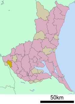
Sakai (境町, Sakai-machi) is a town located in Sashima District, Ibaraki Prefecture, Japan. As of September 2015, the town had an estimated population of 24,598 and a population density 528 persons per km². The total area was 46.59 km².
Contents
- Map of Sakai Sashima District Ibaraki Prefecture Japan
- Geography
- Neighboring municipalities
- History
- Education
- Railway
- Highway
- Noted people from Sakai
- References
Map of Sakai, Sashima District, Ibaraki Prefecture, Japan
Geography
Sakai is located in the flatlands in the very western portion of Ibaraki Prefecture, bordered by Chiba Prefecture to the west. The Tone River, passes through the town.
Neighboring municipalities
History
The area of present-day Sakai was part of Shimōsa Province and was transferred to Ibaraki Prefecture in 1875 after the start of the Meiji period. The area was organized into the town of Sakai with the establishment of the municipalities system on April 1, 1889.
Education
Sakai has five elementary schools, two middle school and one high school
Railway
At present, the town is not served by any passenger railway line.