
Phone number 0280-92-3111 Population 140,770 (Sep 2015) | Region Kantō - Flower Prunus persica Area 123.6 km² Local time Friday 2:29 AM | |
 | ||
Weather 2°C, Wind W at 11 km/h, 66% Humidity Points of interest Koga Park, Koga Castle, Suzume Shrine, Hasekannon | ||
Snow koga ibaraki january 2011
Koga (古河市, Koga-shi) is a city located in Ibaraki Prefecture, in the northern Kantō region of Japan. As of September 2015, the city had an estimated population of 140,770 and a population density of 1140 persons per km². Its total area was 123.58 square kilometres (47.71 sq mi).
Contents
- Snow koga ibaraki january 2011
- Map of Koga Ibaraki Prefecture Japan
- Geography
- Surrounding municipalities
- History
- Economy
- Education
- Railway
- Highway
- Sister city relations
- Local attractions
- Notable people from Koga
- References
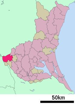
Map of Koga, Ibaraki Prefecture, Japan
Geography
Koga is located in the extreme southwestern corner of Ibaraki Prefecture
Surrounding municipalities
History
Koga developed in the Muromachi period as the Koga kubō, a secondary government created by the Ashikaga shogunate to rule eastern Japan. However, the site has been inhabited since the Jōmon period and was one of the largest centers for iron production in eastern Japan in the Heian period. In the Sengoku period, it developed into a castle town and became the seat of the daimyō of Koga Domain under the Edo period Tokugawa shogunate. The town of Koga was established on April 1, 1889 with the creation of the municipalities system. The modern city was founded on August 1, 1950. On September 12, 2005, Koga absorbed the towns of Sanwa and Sōwa (both from Sashima District) to create the new and expanded city of Koga. The new city hall is now located at the former town of Sōwa.
Economy
Koga was known in the Meiji period through early Showa period as a center for sericulture. At present, the economy is highly industrialized, with the number of factories as second within Ibaraki Prefecture, after Hitachi city.
Education
Koga has 23 elementary schools, nine middle schools, and six high schools.