
Time zone EST (UTC−5) Area 133.1 km² Province Québec | Constituted January 1, 1870 Postal code(s) J0B 2Y0 Population 483 (2011) Area code 819 | |
 | ||
Saint-Malo is a municipality in Quebec, Canada, on the Canada–United States border. Saint-Malo has the highest elevation of any municipality in Quebec. At 640 metres (2,100 ft), local residents live in an environment of forests, farms, and waterways that supply their livelihood.
Contents
- Map of Saint Malo QC Canada
- History
- Population
- Sister City and Village
- Known persons from this town
- References
Map of Saint-Malo, QC, Canada
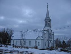
Every September, Saint-Malo holds a Harvest Festival that includes a “country” mass. A popular point of interest is La Montagnaise, a 10 metres (33 ft)-tall observation tower built in 1995, that offers panoramic views of the countryside.
History
The parish of Saint-Malo was established in 1863 by Canadiens and was incorporated as a municipality in 1910. The town's name evokes the Welsh monk Malo, missionary bishop of Brittany, and refers to the hometown of Jacques Cartier, explorer of the New World.
Population
Population trend:
ADJ = adjusted figures due to boundary changes between census years