
Elevation 619 m (2,031 ft) Area 14 km² Dialling code 0165 | Province / Metropolitan city none Time zone CET (UTC+1) Local time Tuesday 6:09 PM Postal code 11020 Number of airports 1 | |
 | ||
Frazioni Angelin, Bagnère, Chabloz, Champapon, Champ-d'Hône, Château d'Entrèves, Chef-Lieu, Clappey, Cognon, Cort, Coutateppaz, La Crétaz, La Croix-Noire, Fontanalle, Gérardin, Gevé, Grand-Chemin, Grande-Charrière, Léméryaz, Loups, Maillod, Méladière, Meysettaz, Nicolin, Olleyes, Ollignan, Pallein, Pin, Prévot, Rouye, Sorreley, Thuvex Demonym(s) Saint-christopherins, Crétoublains Weather 19°C, Wind W at 11 km/h, 32% Humidity | ||
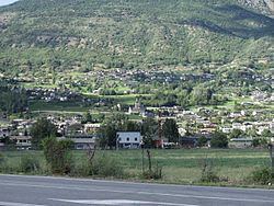
Saint-Christophe (French for Saint Christopher) is a town and comune in the Aosta Valley. It is located east of Aosta, on the left shore of the Dora Baltea.
Contents
Map of 11020 Saint-Christophe, Aosta Valley, Italy
Places of interest
The Passerin d'Entrèves castle is located in this commune.
The Bridge of Grand Arvou is in the Aosta commune nearby.
Transport
Aosta Airport is located in Saint-Christophe. Air Vallée had its head office on the grounds of Aosta Airport.
Twinnings
References
Saint-Christophe, Aosta Valley Wikipedia(Text) CC BY-SA