
Population 67,357 (30 Apr 2011) | ||
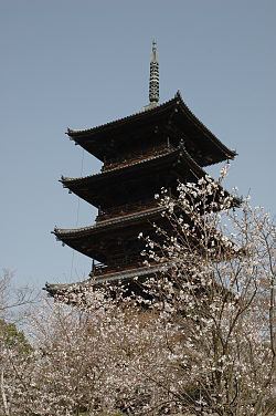 | ||
Time zone Japan Standard Time (UTC+9) Website www.city.soja.okayama.jp Weather 8°C, Wind NW at 3 km/h, 92% Humidity University Okayama Prefectural University Points of interest Ki castle, Bitchūkokubun‑ji Temple, Hōfuku‑ji Temple, Kibiji Hot Spring, Gōkei area | ||
Sōja (総社市, Sōja-shi) is a city located in Okayama Prefecture, Japan.
Contents
- Map of Soja Okayama Prefecture Japan
- History
- Adjacent municipalities
- Rivers
- Mountains
- Sister cities
- References
Map of Soja, Okayama Prefecture, Japan
As of April 30, 2011, the city has an estimated population of 67,357, with 24,623 households and a population density of 317.72 persons per km². The total area is 212.00 km².
History
In the 7th century, Ki Castle was built atop the mountain Kijōyama. Long in ruins, excavation and partial reconstruction began in 1999.
The city was founded on March 31, 1954.
On March 22, 2005, the villages of Yamate and Kiyone (both from Tsukubo District) were merged into Sōja.
Adjacent municipalities
Sōja is surrounded by the following cities and towns, all within Okayama Prefecture.
Rivers
Mountains
Sister cities
Sōja has been twinned with Chino, Nagano in Japan since 1984.
References
Sōja Wikipedia(Text) CC BY-SA