
River mouth Inland Sea0 m (0 ft) Discharge 63.93 m³/s Basin area 2,670 km² | Basin size 2,670 km (1,031 sq mi) Length 111 km Source elevation 1,188 m | |
 | ||
Main source Okayama Prefecture, with tributaries in Hiroshima Prefecture1,188 m (3,898 ft) | ||
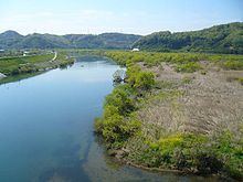
The Takahashi River (高梁川, Takahashi-gawa) is a Class A major river in the western part of Okayama Prefecture. It acts as the main drainage for the Takahashi River Drainage System, and is one of the three main drainage rivers in Okayama Prefecture (the others being the Yoshii River and the Asahi River).
Contents
Map of Takahashi River, Niimi, Okayama Prefecture, Japan
Description
The Takahashi River originates from Akechi Pass near Hanamiyama in Tottori Prefecture, 1,188 m (3,898 ft) above sea level. It flows through the cities of Niimi, Takahashi, Sōja, and Kurashiki, eventually flowing into the Mizushimanada area of the Inland Sea. The mouth is located between the Mizushima and Tamashima areas of Kurashiki. Reconstruction and repairs in 1907 created the eastern and western branches of the Takahashi River.
Major tributaries
References
Takahashi River Wikipedia(Text) CC BY-SA