
Airport type Public Elevation AMSL 787 ft / 240 m Code RUT Phone +1 802-786-8881 | Owner State of Vermont Location North Clarendon Website www.FlyRutlandVT.com Elevation 240 m | |
 | ||
Address 1002 Airport Road, North Clarendon, VT 05759, USA | ||
Rutland – Southern Vermont Regional Airport (IATA: RUT, ICAO: KRUT, FAA LID: RUT), is a state-owned, public use airport located five nautical miles (6 mi, 9 km) south of the central business district of Rutland, a city in Rutland County, Vermont, United States. Situated in North Clarendon, it was formerly known as Rutland State Airport. Scheduled commercial service is subsidized by the Essential Air Service and provided by Cape Air, with three flights daily on nine-passenger Cessna 402 aircraft to Boston with typical flight times of 40 minutes.
Contents
Rutland – Southern Vermont Regional Airport is the closest commercial service airport to the mountain resorts of Killington, Pico, Okemo, Stratton, Bromley, Magic Mountain, and Mount Snow. In addition, Suicide Six and Ascutney Mountain resorts are included in RSVRA's airport service area.
Rutland – Southern Vermont is an FAA Part 139 certificated airport. As per Federal Aviation Administration records, the airport had the following passenger boardings ("enplanements") in recent calendar years:
It is included in the National Plan of Integrated Airport Systems for 2013–2017, which categorized it as a non-primary commercial service airport (between 2,500 and 10,000 enplanements per year). Total air cargo carried in 2006 was approximately 520,000 pounds with 1,560 cargo operations via FedEx and UPS.
Name change
Legislation was introduced into the Vermont Senate in January 2007 to change the official name of the airport to Rutland–Southern Vermont Regional Airport. The state agency of transportation, meanwhile, had plans to change the name to Rutland/Southwest Vermont Regional Airport. This provoked some opposition from the town of Bennington on the grounds that the William H. Morse State Airport (located in the town), is currently known as "Southwest Vermont's Airport". The agency indicated that it intended to go ahead with the name change anyway, claiming that Bennington's opposition came too late in the process. However, the agency changed the name to Rutland Southern Vermont Regional Airport on August 15, 2007.
Facilities and aircraft
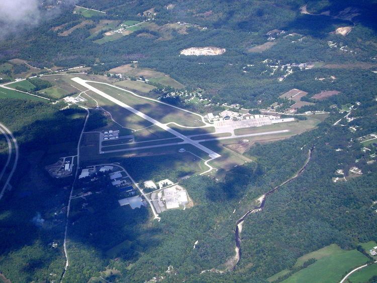
Rutland – Southern Vermont Regional Airport covers an area of 345 acres (140 ha) at an elevation of 787 feet (240 m) above mean sea level. It has two asphalt paved runways: 1/19 is 5,003 by 100 feet (1,525 x 30 m) and 13/31 is 3,170 by 75 feet (966 x 23 m).
For the 12-month period ending July 30, 2011, the airport had 31,770 aircraft operations, an average of 87 per day: 75% general aviation, 22% air taxi, and 3% military. At that time there were 45 aircraft based at this airport: 80% single-engine, 9% multi-engine, 4% jet, 4% helicopter, and 2% ultralight.
Currently, the Rutland – Southern Vermont Regional Airport Technical Advisory Committee is proposing a 1,000 feet (300 m) runway extension to alleviate the constraints posed by the current main runway length and the limited road access to the region. In its current configuration, the main runway is severely limiting to charters, business jets, and 50+ passenger regional jets. Part 91 Subpart K, imposed by the FAA on fractional jet operators in 2005 has reduced runway planning performance by 40 percent.
Airline and destination
The following airline offers scheduled passenger service: