
Airport type Public 7/25 5,094 Elevation 123 m | Owner City of Russellville Elevation AMSL 404 ft / 123 m 5,094 1,553 | |
 | ||
Russellville regional airport changing its local perception
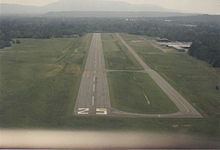
Russellville Regional Airport (ICAO: KRUE, FAA LID: RUE) is a city-owned public-use airport located two nautical miles (3.7 km) southeast of the central business district of Russellville, a city in Pope County, Arkansas, United States. According to the FAA's National Plan of Integrated Airport Systems for 2009–2013, it is categorized as a general aviation facility. It was formerly known as Russellville Municipal Airport.
Contents
- Russellville regional airport changing its local perception
- Plane makes emergency landing at the russellville regional airport
- Facilities and aircraft
- References
Although many U.S. airports use the same three-letter location identifier for the FAA and IATA, this facility is assigned RUE by the FAA but has no designation from the IATA
Plane makes emergency landing at the russellville regional airport
Facilities and aircraft
Russellville Regional Airport covers an area of 307 acres (124 ha) at an elevation of 404 feet (123 m) above mean sea level. It has one runway designated 7/25 with an asphalt surface measuring 5,094 by 75 feet (1,553 x 23 m).
For the 12-month period ending October 31, 2007, the airport had 25,100 aircraft operations, an average of 68 per day: 80% general aviation, 18% air taxi, and 2% military. At that time there were 51 aircraft based at this airport: 90% single-engine, 8% multi-engine and 2% helicopter.