
Country United States County Monmouth Time zone Eastern (EST) (UTC-5) Area 18.43 km² Population 7,006 (2013) Area code 732 | Incorporated June 18, 1907 Elevation 11 m Zip code 07760 Local time Friday 1:42 PM | |
 | ||
Area rank 243rd of 566 in state16th of 53 in county Weather 10°C, Wind SW at 26 km/h, 36% Humidity | ||
Rumson is a borough in Monmouth County, New Jersey, United States and is part of the New York Metropolitan Area. As of the 2010 census, the borough's population was 7,122, reflecting a decline of 15 (-0.2%) from 7,137 in 2000, which had in turn increased by 436 (+6.5%) from 6,701 in 1990.
Contents
- Map of Rumson NJ 07760 USA
- History
- Geography
- Census 2010
- Census 2000
- Parks and recreation
- Local government
- Federal state and county representation
- Politics
- Education
- Roads and highways
- Public transportation
- Notable people
- References
Map of Rumson, NJ 07760, USA
Rumson was formed by an act of the New Jersey Legislature on March 15, 1907, from portions of Shrewsbury Township, based on results of a referendum held on June 18, 1907.
History
Legend has it that the borough's name is derived from early settlers who bought the land from the Native Americans in exchange for some rum. But as far back as 1663, long before the area was officially named Rumson, Native Americans called it "Navarumsunk". Over the years it has been shortened to "Rumson", though sources also talk of a Chief Alumson as a source of the name. Other names Rumson has been known by include Black Point, Port Washington, and Oceanic.
Rumson was purchased by English settlers in pieces. The first purchase is dated January 25, 1665, and it included parts of Middletown. The rest of the area was purchased later that year.
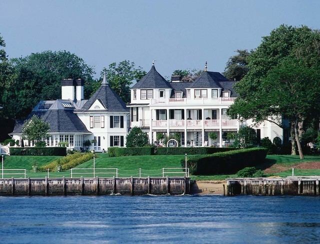
Rumson is known for its many sprawling turn-of-the-century estates located along the shores of the Navesink and Shrewsbury rivers and along historic Rumson Road, which serves as one of Rumson's main thoroughfares. Rumson's many old estates were built as summer homes for wealthy New York bankers and industrialists. The oldest of Rumson's homes was the Tredwell House, named after a family that summered here for almost 100 years. The oldest part of the house being from 1670 once occupied 700 acres (2.8 km2); it was the second oldest building in Monmouth County as of June 2006, when it was destroyed by fire.
In the 19th century Rumson's summer residents enjoyed many activities, such as swimming and boating in the adjacent Navesink River and the Atlantic Ocean, or taking a wagon ride. In winter, residents used the river for ice boating.
Originally a summer colony for wealthy New Yorkers, Rumson has become an upscale suburb.
Geography
According to the United States Census Bureau, the borough had a total area of 7.117 square miles (18.432 km2), including 5.058 square miles (13.101 km2) of land and 2.059 square miles (5.332 km2) of water (28.93%).
Unincorporated communities, localities and place names located partially or completely within the township include East Oceanic, Elsemere, Oceanic, Rumson Bluffs, Rumson Hills and Waterloo.
The borough borders the Monmouth County municipalities of Fair Haven, Little Silver, Middletown Township, Monmouth Beach and Sea Bright.
Census 2010
The 2010 United States Census counted 7,122 people, 2,344 households, and 1,957 families residing in the borough. The population density was 1,408.0 per square mile (543.6/km2). The borough contained 2,585 housing units at an average density of 511.0 per square mile (197.3/km2). The racial makeup of the borough was 97.22% (6,924) White, 0.25% (18) Black or African American, 0.07% (5) Native American, 1.26% (90) Asian, 0.03% (2) Pacific Islander, 0.15% (11) from other races, and 1.01% (72) from two or more races. Hispanics or Latinos of any race were 2.43% (173) of the population.
Out of a total of 2,344 households, 46.8% had children under the age of 18 living with them, 72.4% were married couples living together, 8.6% had a female householder with no husband present, and 16.5% were non-families. 14.3% of all households were made up of individuals, and 7.0% had someone living alone who was 65 years of age or older. The average household size was 3.03 and the average family size was 3.38.
In the borough, 32.5% of the population were under the age of 18, 5.7% from 18 to 24, 18.0% from 25 to 44, 32.4% from 45 to 64, and 11.3% who were 65 years of age or older. The median age was 41.6 years. For every 100 females the census counted 94.0 males, but for 100 females at least 18 years old, it was 89.9 males.
The Census Bureau's 2006-2010 American Community Survey showed that (in 2010 inflation-adjusted dollars) median household income was $134,281 (with a margin of error of +/- $18,300) and the median family income was $157,188 (+/- $28,308). Males had a median income of $140,885 (+/- $25,278) versus $56,071 (+/- $16,014) for females. The per capita income for the borough was $79,388 (+/- $10,219). About 3.8% of families and 4.1% of the population were below the poverty line, including 6.1% of those under age 18 and 0.0% of those age 65 or over.
Census 2000
As of the 2000 United States Census there were 7,137 people, 2,452 households, and 1,988 families residing in the borough. The population density was 1,366.0 people per square mile (527.9/km2). There were 2,610 housing units at an average density of 499.5 per square mile (193.1/km2). The racial makeup of the borough was 97.77% White, 0.24% African American, 0.06% Native American, 1.06% Asian, 0.36% from other races, and 0.50% from two or more races. Hispanic or Latino of any race were 1.39% of the population.
There were 2,452 households out of which 44.2% had children under the age of 18 living with them, 71.3% were married couples living together, 7.8% had a female householder with no husband present, and 18.9% were non-families. 16.8% of all households were made up of individuals and 7.9% had someone living alone who was 65 years of age or older. The average household size was 2.91 and the average family size was 3.29.
In the borough the population was spread out with 31.9% under the age of 18, 3.5% from 18 to 24, 26.6% from 25 to 44, 25.2% from 45 to 64, and 12.8% who are 65 years of age or older. The median resident age is 39.2 years old. The median age is 39 years. For every 100 females there were 93.9 males. For every 100 females age 18 and over, there were 89.6 males.
The median income for a household in the borough was $120,865, and the median income for a family was $140,668. Males had a median income of $100,000 versus $47,260 for females. The per capita income for the borough was $73,692. About 3.4% of families and 3.2% of the population were below the poverty line, including 2.4% of those under age 18 and 0.7% of those age 65 or over.
The most common ancestries of Rumson residents were Irish (33.4%), German (17.9%), Italian (16.4%), English (13.8%), Polish (6.2%) and United States (5.3%).
Parks and recreation
Public parks include Meadowridge Park, Piping Rock Park, Riverside Park, Rogers Park, "Teddy's Playground" at Victory Park, and West Park. The Rumson Country Club is a consolidation of the Rumson Polo Club and the Meadow Yacht Club and the Sea Bright Yacht Club. Bingham Hall serves as a center for social gatherings, recreational activities, and fundraisers.
Local government
Rumson is governed under the Borough form of New Jersey municipal government. The governing body consists of a Mayor and a Borough Council comprising six council members, with all positions elected at-large on a partisan basis as part of the November general election. A Mayor is elected directly by the voters to a four-year term of office. The Borough Council consists of six members elected to serve three-year terms on a staggered basis, with two seats coming up for election each year in a three-year cycle. The Borough form of government used by Rumson, the most common system used in the state, is a "weak mayor / strong council" government in which council members act as the legislative body with the mayor presiding at meetings and voting only in the event of a tie. The mayor can veto ordinances subject to an override by a two-thirds majority vote of the council. The mayor makes committee and liaison assignments for council members, and most appointments are made by the mayor with the advice and consent of the council.
As of 2016, the Mayor of Rumson is Republican John E. Ekdahl, whose term of office ends on December 31, 2019. Members of the Borough Council are Council President Joseph K. Hemphill (R, 2016), Laura R. Atwell (R, 2016), Shaun P. Broderick (R, 2017), John J. Conklin, III (R, 2018), Benjamin W. Day Jr. (R, 2017) and Mark E. Rubin (R, 2018).
Councilmember Frank E. Shanley submitted a letter of resignation that took effect as of December 31, 2014, and was replaced in January 2015 by John J. Conklin, III, who was selected by the Borough Council from a list of three candidates nominated by the Republican municipal committee.
Federal, state and county representation
Rumson is located in the 4th Congressional District and is part of New Jersey's 13th state legislative district. Prior to the 2011 reapportionment following the 2010 Census, Rumson had been in the 11th state legislative district. Prior to the 2010 Census, Rumson had been part of the 12th Congressional District, a change made by the New Jersey Redistricting Commission that took effect in January 2013, based on the results of the November 2012 general elections.
New Jersey's Fourth Congressional District is represented by Christopher Smith (R). New Jersey is represented in the United States Senate by Cory Booker (D, Newark, term ends 2021) and Bob Menendez (D, Paramus, 2019).
For the 2016–2017 session (Senate, General Assembly), the 13th Legislative District of the New Jersey Legislature is represented in the State Senate by Joseph M. Kyrillos (R, Middletown Township) and in the General Assembly by Amy Handlin (R, Middletown Township) and Declan O'Scanlon (R, Little Silver). The Governor of New Jersey is Chris Christie (R, Mendham Township). The Lieutenant Governor of New Jersey is Kim Guadagno (R, Monmouth Beach).
Monmouth County is governed by a Board of Chosen Freeholders consisting of five members who are elected at-large to serve three year terms of office on a staggered basis, with either one or two seats up for election each year as part of the November general election. At an annual reorganization meeting held in the beginning of January, the board selects one of its members to serve as Director and another as Deputy Director. As of 2014, Monmouth County's Freeholders are Freeholder Director Lillian G. Burry (R, Colts Neck Township; term ends December 31, 2014), Freeholder Deputy Director Gary J. Rich, Sr. (R, Spring Lake; 2014), Thomas A. Arnone (R, Neptune City; 2016), John P. Curley (R, Middletown Township; 2015) and Serena DiMaso (R, Holmdel Township; 2016). Constitutional officers elected on a countywide basis are County Clerk M. Claire French (Wall Township), Sheriff Shaun Golden (Farmingdale) and Surrogate Rosemarie D. Peters (Middletown Township).
Politics
As of March 23, 2011, there were a total of 5,166 registered voters in Rumson, of which 953 (18.4%) were registered as Democrats, 1,827 (35.4%) were registered as Republicans and 2,383 (46.1%) were registered as Unaffiliated. There were three voters registered to other parties.
In the 2012 presidential election, Republican Mitt Romney received 68.2% of the vote (2,446 cast), ahead of Democrat Barack Obama with 31.0% (1,111 votes), and other candidates with 0.8% (29 votes), among the 3,610 ballots cast by the borough's 5,384 registered voters (24 ballots were spoiled), for a turnout of 67.1%. In the 2008 presidential election, Republican John McCain received 59.7% of the vote (2,470 cast), ahead of Democrat Barack Obama with 37.3% (1,543 votes) and other candidates with 1.3% (52 votes), among the 4,136 ballots cast by the borough's 5,303 registered voters, for a turnout of 78.0%. In the 2004 presidential election, Republican George W. Bush received 63.8% of the vote (2,590 ballots cast), outpolling Democrat John Kerry with 34.9% (1,418 votes) and other candidates with 0.8% (40 votes), among the 4,060 ballots cast by the borough's 5,084 registered voters, for a turnout percentage of 79.9.
In the 2013 gubernatorial election, Republican Chris Christie received 80.2% of the vote (1,925 cast), ahead of Democrat Barbara Buono with 18.1% (435 votes), and other candidates with 1.6% (39 votes), among the 2,438 ballots cast by the borough's 5,330 registered voters (39 ballots were spoiled), for a turnout of 45.7%. In the 2009 gubernatorial election, Republican Chris Christie received 71.6% of the vote (2,019 ballots cast), ahead of Democrat Jon Corzine with 22.8% (644 votes), Independent Chris Daggett with 4.9% (138 votes) and other candidates with 0.4% (11 votes), among the 2,819 ballots cast by the borough's 5,139 registered voters, yielding a 54.9% turnout.
Education
The Rumson School District serves public school students in pre-kindergarten through eighth grade. As of the 2014-15 school year, the district and its two schools had an enrollment of 977 students and 79.6 classroom teachers (on an FTE basis), for a student–teacher ratio of 12.3:1. Schools in the district (with 2014-15 enrollment data from the National Center for Education Statistics) are Deane-Porter Elementary School (PreK-3, 491 students) and Forrestdale Middle School (4-8, 483 students).
Public school students in ninth through twelfth grades attend Rumson-Fair Haven Regional High School, a regional, four-year comprehensive public high school serving students from both Fair Haven and Rumson, where the school is located. As of the 2014-15 school year, the high school had an enrollment of 938 students and 82.9 classroom teachers (on an FTE basis), for a student–teacher ratio of 11.3:1.
Private schools in Rumson include Holy Cross School for grades K-8, which operates under the auspices of the Roman Catholic Diocese of Trenton. In 2015, Holy Cross School was one of 15 schools in New Jersey, and one of six private schools, recognized as a National Blue Ribbon School in the exemplary high performing category by the United States Department of Education.
Founded in 1926 and developed under the principles of its organizer B. Lord Buckley, Rumson Country Day School serves students in preschool through eighth grade and was recognized in 1999 by the National Blue Ribbon Schools Program.
Roads and highways
As of May 2010, the borough had a total of 49.56 miles (79.76 km) of roadways, of which 40.15 miles (64.62 km) were maintained by the municipality and 9.41 miles (15.14 km) by Monmouth County.
Public transportation
Transportation to New York is available via NJ Transit's train service from either the Little Silver or Red Bank stations on the North Jersey Coast Line.
Many of Rumson's residents work in the financial services industry and commute to Wall Street on the high-speed SeaStreak ferry that leaves from nearby Atlantic Highlands. The ferry ride is 40 minutes to the foot of Wall Street or an hour to Midtown Manhattan.
NJ Transit offers local bus service on the 835 route.
Notable people
People who were born in, residents of, or otherwise closely associated with Rumson include: