
Country Nepal Time zone NPT (UTC+5:45) Area 2,877 km² | Headquarters Musikot Website www.ddcrukum.gov.np | |
 | ||
Region Mid-Western Development Region, Nepal (grey) | ||
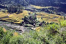
Tourism rukum
Rukum District(Nepali: रुकुम जिल्ला Listen , is a "hill" and "mountain" district some 280 km west of Kathmandu partially belonging to Province No. 5 and partially to Province No. 6. Rukum covers an area of 2,877 km² with population of 188,438 in 2001 and 207,290 in 2011. Musikot (also called Jhumlikhalanga) is the district's administrative center. Rukum district has potential tourist attractions that remain largely unexplored including yarsagumba (Ophiocordyceps sinensis) collection caravan destinations, historical sites from the ten-year insurrection including the seat of a breakaway government in Banphikot, eastern Rukum, and the so-called Guerrilla Trek passes through this area that was a hotbed for recruiting and training as well as a battleground during Nepal's civil war (1996-2006). (. There is 5,911 metres (19,393 ft) Mt. Sisne (Nepali: सिस्ने हिमाल), the westernmost high peak in the Dhaulagiri massif. Locals refer to Sisne as Hiunchuli (hiu: snow; chuli: top) and it is considered sacred as the abode of deities Masta and Saikumari. Climbing history on the mountain is not well documented and an eight-man expedition led by Man Bahadur Khatri reached the summit ridge in May 2013. Rukumkot, a prominent village in Rukum is referred to as "the place of 52 lakes and 53 hills". Rukumkot (Nepali: all of them Shyarpu Tal (Lake) is largest lake in Rukum रुकुमकोट) has a beautiful pond called Rukmini Tal or locally Kamal Dhaha for its lotus flowers (kamal: lotus). Nearby are notable temples called Barah and Sibalaya, and caves such as Deurali Cave.
Contents
- Tourism rukum
- Map of Rukum Nepal
- Geography and Climate
- Transport
- Rapti Highway
- Mid Hill Highway
- Chaurjahari Airport
- Rukum Salle Airport
- Civil War
- Villages Development Committees VDCs
- Maps
- References
Map of Rukum, Nepal
Geography and Climate
Rukum district is the northernmost part of Rapti Zone. It is in the basin of Bheri River, a major tributary of the Karnali. Most of Rukum is drained by west-flowing tributaries such as Uttar Ganga draining Dhorpatan Valley and to the north of that the Sani Bheri draining southern slopes of the western Dhaulagiri Himalaya.
Elevation ranges from below 800 meters along the Bheri and its lowest tributaries to about 6,000 meters in the Dhaulagiris with a range of climates from sub-tropical to perpetual snow and ice. Agricultural use ranges from irrigated rice cultivation through upland cultivation of maize, barley, wheat, potatoes and fruit, to sub-alpine and alpine pasturage reaching about 4,500 meters.
Transport
Rukum District is considered remote and air service is irregular, but with recent road building, bus and jeep service are now available with links to the southern plains and major cities including Kathmandu. Two airports offer safe but rudimentary facilities for passenger flights, mainly from Nepalganj, and Kathmandu. The Rapti Highway is under construction (as of 2010) to connect Musikot to Salyan Khalanga, Tulsipur and Mahendra Highway to the south. On the other hand, Nepal's dream project "Mid-Hill Highway" is under construction.
Rapti Highway
Dang-Salyan-Rukum: About 4 hours bus ride from Dang Tulsipur to Rukum Musikot.
Mid-Hill Highway
Mid-Hill Highway is under construction, and a national pride project that passes through 12 zones, 24 districts, and 215 V.D.Cs. With a total length of 1,767 km, the highway connects Chiyo Bhanjyang of Pachthar district in the east with Jhulaghat of Baitadi district in the west.
Bus ride from Kathmandu takes up to 24 hours to Musikot.
The two airports in Rukum are in Chaurjahari (Nepali: चौरजहारी) and Salle (Nepali: सल्ले).
Chaurjahari Airport
Near the Bheri River. 762 m above sea level and accessible by footpaths and horse trails only, with a grass runway 850 m long and 30 m wide. It was the primary mode of travel to Rukum for government, NGO personnel, aid workers and backpackers before the civil war. During the conflict the security situation deteriorated and the local police station was shut down. The airport has 10 aircraft parking spaces.
The flight from Nepalganj to Rukum Salle airport takes 15–20 minutes.
Rukum Salle Airport
Located near Musikot, the district headquarters. It is accessible is foot way and road transport also since Rapti Highway has touched Salle airport also. Its runway is 650 meters long with capability of parking of 4 aircraft at once.
The flight from Kathmandu to Rukum Salle airport takes about 90 minutes, while the flight from Nepalganj takes about 20 minutes.
Civil War
Rukum was a flashpoint of the Maoist insurgency, along with neighboring Rolpa district. Rukum became a stronghold and was controlled by insurgents throughout the conflict. Many Maoist leaders came from this district, as well as many martyred insurgents. But now Rukum is known as a new tourism destination in Nepal.The Government of Nepal with the Nepal Tourism Board, Rukum District officials, Maoists party leaders, and a foreign author of a guidebook and map to the area launched the Guerrilla Trek (Peace Trail) with a ceremony in Kathmandu in Oct 2012.