
- elevation 685 m (2,247 ft) Length 496 km Basin area 14,350 km² | - elevation 0 m (0 ft) Discharge 340 m³/s Basin area 14,350 km² Mouth Gulf of Saint Lawrence | |
 | ||
- average 340 m/s (12,010 cu ft/s) | ||
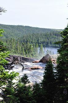
The romaine river in quebec canada
The Romaine River is a river in the Côte-Nord region of the Canadian province of Quebec. It is 496 kilometres (308 mi) long. It is not to be confused with the Olomane River that is 220 kilometres (140 mi) to the east and had the same name for a long time.
Contents
- The romaine river in quebec canada
- Map of RiviC3A8re Romaine Division No 10 Subd C NL Canada
- Romaine river
- Tributaries
- Hydroelectric development
- Fauna
- References
Map of Rivi%C3%A8re Romaine, Division No. 10, Subd. C, NL, Canada
The Romaine River has its source on the boundary between the Atlantic and Saint Lawrence watersheds, and flows first through a series of lakes, including Long, Marc, Brûlé (Burnt), Lavoie, Anderson, and Lozeau. This portion of the river to just past the confluence with Uauahkue Patauan Creek forms the disputed boundary between Quebec and Labrador. Then it flows in a mostly southerly direction until a dozen miles from the coast where it takes a sharp turn to the west, flowing through a series of swampy waterlogged small lakes. The Romaine River drains into the Jacques Cartier Strait, opposite the Mingan Archipelago, that is part of the Gulf of Saint Lawrence.
The name Romaine, in use since the end of the 19th century, is a French adaptation of the Native American term Ouraman or Ulaman as noted by Jean-Baptiste-Louis Franquelin in 1685, while Jacques-Nicolas Bellin wrote Ramane on his map of 1744. It comes from unaman, meaning "vermilion" or "red ochre". Deposits of this material are found on the banks of the Olomane River.
Romaine river
Tributaries
The significant tributaries of the Romaine River are (in upstream order):
Hydroelectric development
The Romaine River is being developed by Hydro-Québec for hydro-electric power generation. Construction started in 2009 on a new hydroelectric plant, along with four rock-filled dams and a 150 kilometres (93 mi) long access road, that will take 11 years to build at an estimated cost of C$6.5 billion. Called "the biggest construction project in Canada", the project will employ an estimated 2000 people between 2012 and 2016, and create some C$3.5 billion in economic spinoffs.
The final project will include four new power plants with a total installed capacity of more than 1550 MW and an average annual production of 7.5 TWh per year:
This project is controversial however, as the cost of electricity production will likely be higher than the price at which the electricity will be sold, as shown in a 2010 documentary called "Chercher le courant", "Seeking The Current" in English, by Nicolas Boisclair and Alexis de Gheldère. The film argues that the Romaine project is unnecessary, unprofitable, and ecologically destructive. It is also opposed by the Fondation Rivières.
Fauna
The Romaine River is home to the Atlantic salmon that swims 52 kilometres (32 mi) upstream as far as the Grande Chute. Other fish species are brook trout (found along the river's entire length), lake trout (in most lakes), and landlocked salmon (upstream of Grande Chute).