
Airport type Public Website www.RollaCity.org/... Phone +1 573-299-4498 | Elevation AMSL 1,148 ft / 350 m 4/22 5,500 | |
 | ||
Address 901 N Elm St, Rolla, MO 65401, USA Similar Rolla Downtown, Waynesvi Regional Airport‑Tbn, USA Express, Missouri University of Scienc, Rolla Engineeri Departme | ||
Rolla National Airport (IATA: VIH, ICAO: KVIH, FAA LID: VIH) is a public use airport in Maries County, Missouri, United States. It is owned by the City of Rolla (in adjacent Phelps County) and located 11 nautical miles (13 mi, 20 km) north of its central business district. The airport is one nautical mile (2 km) northwest of Vichy, Missouri. It is included in the National Plan of Integrated Airport Systems for 2011–2015, which categorized it as a general aviation facility.
Contents
Ifr approach into rolla national airport kvih
History
The airport was originally built by the United States Army Air Forces in 1942 as a sub-base for Sedalia Army Airfield during World War II. It was designated as Vichy Army Airfield, and was used by I Troop Carrier Command for training. The Third Air Force 76th Reconnaissance Group operated L-1 Vigilant and L-4 Grasshopper light observation aircraft from the airfield in the spring of 1943 in support of Army training at Fort Leonard Wood.
The airfield was vacated by the Air Force in March 1946; however it was re-activated by the United States Navy which used it as an Outlying Field (OLF) for Naval Air Station St. Louis. When the Navy ended its use, it was deeded to the city of Rolla in 1957 and became Rolla National Airport.
In August 1959, the USAF Air Defense Command established site "P-70C (later Z-70C)" at the airport. It was an Air Defense Radar Gap-Filler Annex, equipped with an Bendix AN/FPS-18 Radar medium-range search Radar 38°08′08″N 091°46′24″W, assigned to the 798th Radar Squadron, Belleville AFS, Illinois. The station was inactivated in late 1968. Both building and radar tower (but now without radome) are still extant. The radome was removed in November 2011.
Facilities and aircraft
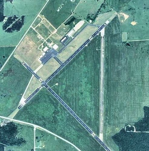
Rolla National Airport covers an area of 1,370 acres (554 ha) at an elevation of 1,148 feet (350 m) above mean sea level. It has two runways, designated 4/22 and 13/31, each with an asphalt surface measuring 5,500 by 100 feet (1,676 x 30 m).
For the 12-month period ending March 31, 2010, the airport had 10,570 aircraft operations, an average of 28 per day: 95% general aviation, 3% air taxi, and 2% military. At that time there were 68 aircraft based at this airport: 85% single-engine and 15% multi-engine.