
 | ||
Similar Otago Central Rail Trail, Dunedin Railways, Danseys Pass, Mount Cargill, Hayes Engineering Works | ||
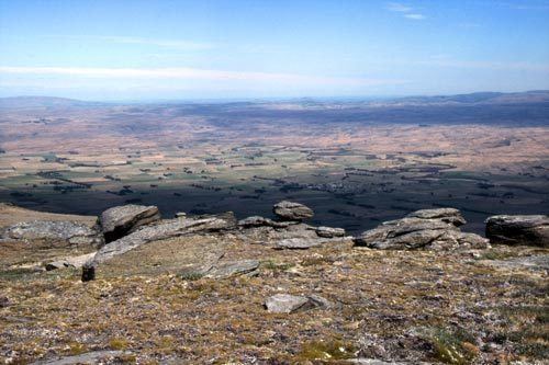
Unusual tarn on rock and pillar range central otago new zealand
The Rock and Pillar Range of high hills is located in the Maniototo, an area of inland Otago, New Zealand. They are surrounded by the Taieri River, which has its source in the range, flowing out across the scroll plain at Paerau, before almost doubling back on itself at Waipiata and flowing back along the other side through the Strath-Taieri. The town of Middlemarch lies close to the Taieri to the east of the range, and Patearoa lies to the northwest.
Contents
- Unusual tarn on rock and pillar range central otago new zealand
- Map of Rock and Pillar Range Paerau 9398 New Zealand
- Alpine plants rock and pillar range
- Fauna and Flora
- References
Map of Rock and Pillar Range, Paerau 9398, New Zealand
The Rock and Pillars are a horst range, caused by movement on two parallel faults uplifting the area in between. Thus, the range is characterised by a very flat top, with steep escarpments on either side. The Great Moss Swamp lies on the upper surface of the range. There is a persistent and highly unusual cloud formation associated with the range. This strange cloud formation, found only in one or two places in the world, is more or less stationary and is called the Taieri Pet by the local inhabitants. It is formed by high north-westerly winds being forced upward over the Rock & Pillar range. Big Hut, situated near the summit of the range, is available for public use.
The range takes its name from the rock formations that cover parts of it. The highest point in the range is Summit Rock, at 1450 metres (4756 feet), and several lower points include Stonehenge (1380 m) and McPhee's Rock (1013 m).
Alpine plants rock and pillar range
Fauna and Flora
The nationally endangered Burgan Skink is endemic to the Rock and Pillar range.