
Location New Zealand | Elevation 935 m | |
 | ||
Similar | ||
Trail riding danseys pass 2015
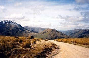
Danseys Pass (often incorrectly referred to as Dansey's Pass or Dansey Pass) (el. 935 m.) is a mountain pass located in the Kakanui Mountains, between Central Otago and North Otago, in the South Island of New Zealand.
Contents
Map of Danseys Pass, Kyeburn Diggings 9396, New Zealand
It lies between the Maniototo plain (part of the Taieri River water catchment) and the northern foothills of the Kakanui Mountains (part of the Waitaki River catchment). Much of the road going over Danseys Pass is unsealed. The road was built for the owners of large sheep runs, the brothers Allan McLean and John McLean.
Though not a major arterial road, the pass is a fairly well-used link between the towns of Naseby and Ranfurly in the south and Duntroon in the Mackenzie Basin of inland Canterbury. Also, if State Highway 1 between Hampden and Moeraki is closed, it is closest detour, despite adding over 100 km to the journey.
The locality of Danseys Pass is located approximately halfway between the pass and Duntroon on the eastern side. Confusingly, however, the historic Danseys Pass Coach Inn / Danseys Pass Hotel is located on the western side, at the locality known as Kyeburn Diggings or Upper Kyeburn, north of Kyeburn.