
Country Canada River mouth 0 ft (0 m) Province Québec | Main source 479 m (1,572 ft) Length 101.3 km (62.9 mi) | |
 | ||
Similar Parc des Chutes, Musée du Bas Saint‑Laurent, Centre Premier Tech, Rivière‑du‑Loup Town Hall, Orford Express | ||
The Rivière du Loup is a river in eastern Quebec, Canada, which empties on the south shore of Saint Lawrence River at the city of Rivière-du-Loup. She throws herself into it in the city of Rivière-du-Loup which is part of regional county municipality (RCM) Rivière-du-Loup, in the administrative region of Bas-Saint-Laurent, in Quebec, in Canada.
Contents
There is a hydroelectric plant on the river near the city.
The "Rivière du Loup" flows in regional county municipalities of:
Geography
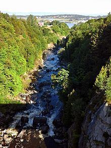
The "rivière du Loup" (English: "river of the Wolf") has its source in "Lac Saint-Pierre" in the "canton of Painchaud", within Notre Dame Mountains, the Zone d'exploitation contrôlée (English: Controlled Harvesting Zone) of Zec Chapais in the regional county municipality (RCM) Kamouraska. This lake is located 36.5 km east of the southeast coast of the Gulf of St. Lawrence, 20.1 km southeast of the village center of Saint-Bruno-of-Kamouraska and 19.4 kilometers south-west of the village center of Saint-Athanase. The "rivière du Loup" flows to the North over 101.3 kilometers.
The "Rivière du Loup" pours over a long strike (at low tide) in the "Cayes to Carrier Bay" which is bordered on the north side by the "Pointe-de-Rivière-du-Loup". From Malin rock, this edge advances towards the southwest in the St. Lawrence River over a length of 1.6 km, including the end where a marina is fitted there.
This confluence is located in front of the "Île aux Lièvres" (English: Island of Hare) and the "Île Blanche" (English: White Island), located 10.0 km offshore and part of the municipality of Saint-André. The Channel "Pot à l'Eau-de-Vie" (English: "Pot of stream water") separates the island and the southeast coast of St. Lawrence River. The "Réserve faunique des Îles de l'Estuaire" (English: "Wildlife Reserve of the Estuary Islands") was built on a set of islands between the "Île aux Lièvres" and the channel "Pot à l'Eau-de-Vie".
Toponymy
The river's name means Wolf River in French and may have come from a native tribe known as "Les Loups" or from the many seals, known in French as loup-marin, once found at the river's mouth.