
River mouth River Trent0 ft (0 m) Source elevation 18 m Mouth elevation 0 | Length 42 km Country United Kingdom | |
 | ||
Tributaries Left:River Poulter, River Ryton | ||
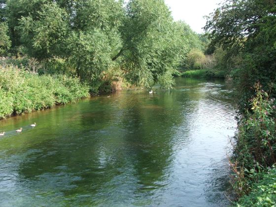
River idle retford nottinghamshire
The River Idle is a river in Nottinghamshire, England. Its source is the confluence of the River Maun and River Meden, near Markham Moor. From there, it flows north through Retford and Bawtry before entering the River Trent at Stockwith near Misterton. The county boundary with South Yorkshire follows the river for a short distance near Bawtry, and the border with Lincolnshire does the same at Idle Stop. Originally, it flowed northwards from Idle Stop to meet the River Don on Hatfield Chase, but was diverted eastwards by drainage engineers in 1628.
Contents
- River idle retford nottinghamshire
- Map of River Idle United Kingdom
- Foraging fish in the river idle andrew pledger loughborough university research
- Hydrology
- History
- Drainage
- Navigation
- Conservation
- Course
- References
Map of River Idle, United Kingdom
Most of the land surrounding the river is a broad flood plain. Between Retford and Bawtry, the floodplain is partly occupied by a number of sand and gravel pits, where exhausted forming public lakes for fishing, while beyond Bawtry, the river is constrained by high flood banks, to allow the low-lying areas to be drained for agriculture. Its main tributaries are the River Poulter and the River Ryton.
The river is navigable to Bawtry, although navigation rights were removed in 1972. It is also important for conservation, with the Idle Washlands and some of the sand and gravel pits of the Idle Valley being designated Sites of Special Scientific Interest.
Foraging fish in the river idle andrew pledger loughborough university research
Hydrology
To the west of the region through which the river flows, the underlying geology is an extensive water-bearing porous rock structure called the Magnesian Limestone aquifer. Magnesian limestone is so named because if contains quantities of the mineral Dolomite, which is rich in Magnesium. Further to the east, this rock is covered by another layer of porous rock called the Triassic Sherwood Sandstone aquifer, which is the major geological component of the area. Continuing eastwards, both are then covered by a layer of Mercia mudstone. Where these aquifers reach the surface, they often supply water to the river system, but can also take water from it. This is affected by the extraction of groundwater, particularly for public water supply, and by fracturing of the aquifers as a result of subsidence caused by deep coal mining.
The catchment for the River Idle covers some 280 square miles (730 km2), which has an average annual rainfall of 24 inches (610 mm) (based on figures from 1961 to 1990). About a third of this finds its way into the rivers. Water quality is moderate. The Environment Agency use a six-stage rating scale, from 'A' to 'F', called the General Quality Assessment, to classify rivers. 'A' on the GQA is the best quality of water, while 'F' is the poorest. Factors which affect the quality are levels of ammonia, levels of dissolved oxygen and the Biochemical oxygen demand (BOD), which measures the amount of dissolved oxygen needed by organisms to break down organic matter in the water. These factors are generally worse when the water is discharged from sewage treatment processes, and tend to be worse in summer, when such discharges make up a greater proportion of the total flow in the river. The tributaries of the Idle are rated at 'C' on the GQA scale, because they pass through urban areas, and there are significant discharges to the rivers from sewage treatment works. The average flow in the River Maun is around 13 Mld (megalitres per day) in dry weather, which is supplemented by Mansfield sewage treatment works, which discharges nearly 23 Mld. Water quality does not improve in the Idle, and remains at 'C' on the GQA scale all the way to the Trent. The Environment Agency maintain gauging stations to measure the flow in the river near the junction with the River Poulter, and to the east of Mattersey.
History
Until the 17th century, the river flowed northwards from a place which subsequently became known as 'Idle Stop', across Hatfield Chase. To the west of Wroot, the River Torne formed two channels, both of which joined the Idle to the east of Wroot, and the Idle continued to join the River Don to the north west of Sandtoft. From Dirtness, the Don flowed to the north east, to Adlingfleet, where it joined the River Trent near to its confluence with the River Ouse. However, in 1626 the Dutch drainage engineer Cornelius Vermuyden was appointed by King Charles I to drain Hatfield Chase. Vermuyden brought over a number of Walloon partners, known as the Participants, who took shares and performed the drainage work, which was completed two years later. The Idle was affected by this work. Its course was blocked by a dam constructed at Idle Stop, and its waters were diverted along the Bycarrs Dyke, a Roman navigation channel, which joined the River Trent at West Stockwith. In order to isolate the river from Hatfield Chase, a barrier bank was constructed along the northern edge of this channel, for 5 miles (8 km) from the dam to Stockwith. A navigable sluice was built about 1 mile (1.6 km) from the river mouth at Misterton Soss by Vermuyden's nephew, John Liens, between 1629 and 1630, to prevent water from the Trent flooding the land to the south of Bycarrs Dike. The construction was of timber, with high banks running to the Trent on both sides of the channel. Lifting gates gave access to a lock chamber 60 by 18 feet (18.3 by 5.5 m), which could be used when the Trent was not in flood. Liens was compelled to carry out the work by the Court of Sewers, to prevent the flooding of Misterton and Haxey Commons.
A drainage channel called the New Idle River was constructed in a straight line from Idle Stop to Dirtness, crossing the Torne by a tunnel at Tunnel Pits, about halfway along its course. From Dirtness, it was routed to the east to Hirst, where it was joined by the new course of the Torne, and the two channels ran parallel to an outfall at Althorpe on the Trent. There was a great deal of dissatisfaction with the drainage scheme, which resulted in claims and counter-claims in the courts. A petition brought to the Privy Council by several local authorities from Nottinghamshire, alleging that the Participants had caused damage, was judged in their favour. The Commission of Sewers decided that a new cut was needed, to carry water from Misterton, Gringley and Everton to the Trent, and so relieve the Idle, but only about 1.2 miles (2 km) was constructed before landowners objected and the work was not completed. During the English civil war, much of the scheme was damaged. The Participants supported the King, while commoners on the Isle of Axholme supported the Parliamentarians. Alleging that the Royalists would invade Axholme from the south, they broke down Misterton sluice and the Snow Sewer flood gates in 1642 or 1643, causing widespread flooding and damage estimated at £20,000. The Sheriff of Lincoln repaired both structures, but a band of 400 villagers destroyed them again. Legal action and rioting continued for some years. Nathaniel Reading, acting for the Participants, raised an 'army' in 1656, and fought a total of 31 pitched battles, including several against the men of Misterton and Gringley. It was not until 1719 that the issues were finally settled and peace returned to the area.
Daniel Defoe visited the river in the early 18th century, and described it as full and quick, though not rapid and unsafe ... with a deep channel, which carries hoys, lighters, barges or flat-bottom'd vessels. He went on to describe the port of Bawtry, which was the limit of navigation, as famous all over the south part of the West Riding of Yorkshire, for it is the place wither all their heavy goods are carried. Traffic included lead from Derbyshire, brought to Bawtry by pack horse, Swedish iron bound for Sheffield, cutlery from Sheffield, iron products from furnaces in Nottinghamshire and Derbyshire, together with coal and timber.
In 1720, the merchants of East Retford obtained an Act of Parliament to allow them to extend the navigation to Retford, and to charge tolls. Although no work appears to have been carried out, the plans were still being considered in 1757, by which time much of the river's trade had been lost, the Derbyshire lead trade now using an improved River Derwent, and the Sheffield trade using the River Don Navigation.
Boats navigating to Bawtry were shallow-drafted, and were approximately 48 by 14 feet (14.6 by 4.3 m), capable of carrying between 12 and 24 tons. Trade in 1767 amounted to 4,415 tons, of which some 25 per cent was lead, but the opening of the Chesterfield Canal in 1777 provided a more convenient outlet for most goods, and by 1828 commercial traffic had ceased to use the river. There was a wharf at Bawtry, but a large bend just above it was in the way when the Great Northern Railway was constructed. The Railway Company constructed a new cut for the river, but the channel to the wharf soon silted up. Navigation rights on the river ceased with the passing of the Trent River Authority (General Powers) Act of 1972, although boats can still use it.
Drainage
The banks of the river below Bawtry have been raised so that the river acts as a high level carrier for the drainage of the surrounding land. The area between the river and the Chesterfield Canal to the south and the Warping Drain to the north is drained by a network of drainage ditches, which are connected to the river by a number of sluices and pumping stations. Water is pumped from the ditches to avoid flooding of the agricultural land, although the pumping station at Gringley can operate in reverse, supplying water to the ditches for irrigation when required. The outflow into the River Trent is controlled by a pumping station and two sluices. A vertical sluice gate protects the entrance to the Idle, and the pumping station and another sluice are situated further back. When the water level in the Trent is low, the sluice gates allow water to leave the Idle by gravity, but at high tide, four electric pumps are used to pump the outflow into the space between the sluice gates until it can again discharge by gravity. The pumping station was commissioned in 1981, and was the largest all-electric pumping station in Britain at the time. When all four pumps are operating, it can discharge 2,124 tons per minute (3,059 Mld).
A large drainage ditch called the Mother Drain runs parallel to the lower river for the final 10 miles (16 km). This was constructed between 1796 and 1801 by the engineer Thomas Dyson, to collect water from the low-lying land to the south of the river. Vermuyden's single sluice was replaced by a triple sluice at this time. The Mother Drain was pumped into the river by two pumping stations at Misterton Soss, the first example of steam engines being used for land drainage outside of the Fens. The first station, called Kate, was built in 1828 and used a 40 horsepower (30 kW) beam engine to drive a 34-foot (10 m) scoop wheel. The wheel was replaced by a centrifugal pump in 1890, and the beam engine was replaced by a 135-horsepower (101 kW) twin cylinder steam engine in 1895. The second, called Ada, was built in 1839, and another 34-foot (10 m) scoop wheel was powered by a beam engine supplied by Booth & Co, who were based at Park Ironworks in Sheffield. Both became redundant in 1941, when the drainage system was re-organised to feed excess water to a new pumping station at Gringley, containing two Ruston diesel engines driving Gwynnes Limited pumps. By 1910, there was a bridge at this point which included tide gates, similar to the V-gates of a lock, which were designed to shut as the level in the River Trent rose. Both the north and the south pumping station are Grade II* listed buildings, and the south building carries an inscribed stone stating "These works erected 1828, Francis Raynes, George Kelk, William Gauntley (Commissioners), Alfred Smith, Engineer". They have been saved from dereliction by being converted to residences, their function performed by the modern electric pumping station at Gringley, while the tide gates have been replaced by the vertical sluice at the entrance to the river.
The low-lying region to the south of the Mother Drain is managed by the Everton Internal Drainage Board, who maintain around 34 miles (55 km) of watercourses. The Board has been operating in its present form since 1945, but is the successor to a similar body established in 1796 during the reign of King George III. The watercourses are pumped to the river at Gringley and Scaftworth. The Gringley pumping station was fitted with new diesel pumps in the 1940s, and was upgraded again in 2005 when electric pumps and an automatic weedscreen cleaner were installed.
On the north side of the river, drainage is managed by the Finningley Internal Drainage Board, who are responsible for the maintenance of 24.7 miles (39.8 km) of drains and ditches, which feed surplus water to four pumping stations. Hunters Hill, which is just above Haxey Gate bridge, and Idle Stop pumping stations are situated on the banks of the Idle, while Austerfield pumping station is set further back on the Austerfield Drain. The fourth pumping station is at Langholme, on the northern edge of the IDB area, and feeds into the Warping Drain, which joins the River Trent at Owston Ferry.
Above Idle Stop, the river flows through an area where drainage is the responsibility of the Rivers Idle and Ryton Internal Drainage Board. The IDB was re-formed in 1987, its responsibilities having previously been performed by the Severn Trent Water Authority, and manages 53 miles (85 km) of watercourses. Those to the west of the Idle drain into the river by gravity at a number of locations, but the region to the east of the river and to the north of Retford drains to a single outfall at Wiseton, where a pumping station pumps the water into the river when river levels are too high for gravity flow.
Navigation
The river is navigable for around 11 miles (18 km) from West Stockwith to Bawtry. Access to the river is through the sluice gates, and so the Environment Agency, who are responsible for the waterway, require 48 hours notice of intent to enter the river. There is also a high toll for doing so, with the result that most boaters that enter the river do so as part of a group, so that the cost can be shared. The space between the two sluices is effectively used as a very large lock, capable of holding a number of boats. Entrance through the first sluice is only possible for an hour either side of high tide. The Environment Agency also require all boaters to sign an indemnity form, which absolves them of any responsibility for loss or damage to boats.
Boats using the river can reach Bawtry bridge. Size is restricted to 59.7 by 18 feet (18.2 by 5.5 m), with a draft of 2.5 feet (0.76 m) and headroom of 9 feet (2.7 m). There are no public moorings. Large boats can turn round with care either side of Bawtry bridge, and at the point where the River Ryton joins the Idle. Above this point, the river can be navigated by canoes all the way from its source. Access to the river can be gained from a bridge over the River Meden some 110 yards (100 m) above the junction with the River Maun, where the Idle starts.
The river also provides water for the Chesterfield Canal. A feeder was constructed in the 1770s, which left the river some 2 miles (3.2 km) above the Retford aqueduct, so that water could flow by gravity to the canal. This arrangement was replaced by an electric pumping station at the foot of the aqueduct in the 1970s.
Conservation
There are four areas of grassland adjacent to the lower Idle, which are subject to periodic flooding, and which provide habitat for wintering and breeding birds. They form the Idle Washlands Site of Special Scientific Interest (SSSI). Historically, a much greater area would have functioned in this way, but much of it is now cut off from the river by high flood defence banks. The Washlands SSSI once covered an area of 250 hectares, which was used as grazing pasture during the summer months and was often covered by shallow flooding in the winter, but during the 1980s, further flood defence work and land drainage reduced this area to 88 hectares. Some work has been carried out under the National Environment Programme to ensure that the wildfowl and wader habitat is not lost completely, and the Environment Agency have produced a water level management plan to further protect the SSSI. Parts of the Mother Drain are also a designated SSSI.
Further up-river, the Sutton and Lound gravel pits are still part of an active quarrying operation which is run by the construction group Tarmac, but some 316 hectares have been designated as an SSSI. They provide an important wetland habitat for a large variety of birds. The pits won the 2008 "British Trust for Ornithology - British Energy Business Bird Challenge" in the category for quarries over 100 ha. A total of 172 different species of birds were recorded, including a number of birds which normally occupy the coastal fringes rather than inland sites. These include ringed plover, little ringed plover, shelduck and oystercatchers. Other birds seen include the black-necked grebe, which is rare in the United Kingdom, and the nightingale, which was extinct in Nottinghamshire before 2004. The Nottinghamshire Wildlife Trust have been active in planting reeds to improve the habitat, which are grown at Langford Quarry in a joint venture between Tarmac and the Royal Society for the Protection of Birds.
Course
The river is largely rural in character, although it passes through the centre of Retford and skirts the south-eastern fringe of Bawtry. The village of Eaton, on the southern edge of the town of East Retford, is believed to occupy the site of a battle in 616 in which the East Angles under Raedwald defeated the Northumbrians under Æthelfrith, and Æthelfrith was killed. The battle resulted in the establishment of Edwin as king of Northumbria.
Bawtry bridge, which carries the A631 road to Gainsborough over the river, was constructed in 1810 by Mr Flavel of Wetherby, at a cost of £3,000. It consists of a large central arch flanked by a slightly smaller arch on both sides. The road was widened in 1940, by extending the bridge on its south side, but retains its original character because the south facade was carefully removed and reused to face the new construction.