
Elevation 13,143 ft (4,006 m) Width 9 mi (14 km) EW Parent range Sierra Nevada | Length 15 mi (24 km) NS Period Cretaceous | |
 | ||
Mountains Similar Minarets, Sierra Nevada, Mount Ritter, Banner Peak, Thousand Island Lake | ||
Ritter range high tour
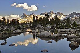
The Ritter Range is a small mountain range within California's Sierra Nevada. Most of the mountain range lies within the Ansel Adams Wilderness. The Range is easily viewed from Minaret Summit, which is accessible by motor vehicle. The Ritter Range is most easily accessible from Mammoth Lakes, where hiking trails lead to lakes throughout the range. The John Muir Trail passes by many lakes within the Ritter Range. The most prominent peaks of the Ritter Range are Mount Ritter, at 13,143 feet, Banner Peak, at 12,936 feet, and the Minarets, a group of sharp peaks south of Mt. Ritter. Thousand Island Lake, Ediza Lake, Garnet Lake, Lake Catherine, Minaret Lake, Cecile Lake, and Shadow Lake all lie within the Ritter Range, and are accessible by trail.
Contents
Map of Ritter Range, California, USA
The range is named for Carl Ritter, who had been a teacher of Josiah Whitney when he was a student in Berlin in the 1840s."
The Ritter Range, near the Minarets and Minaret Lake, was the site of the plane crash of Steve Fossett in 2007.