
District Gudbrandsdal Area rank 78 in Norway Area 1,248 km² Local time Thursday 2:26 PM | Administrative centre Ringebu Demonym(s) Ringbygging Population 4,611 (2004) | |
 | ||
Weather -3°C, Wind SE at 10 km/h, 83% Humidity Points of interest Rondane National Park, Ringebu Stave Church, Muen | ||
Ringebu is a municipality in Oppland county, Norway. It is part of the traditional region of Gudbrandsdal. The administrative centre of the municipality is the village of Vålebru.
Contents
Map of Ringebu Municipality, Norway
The municipality of Ringebu was established on 1 January 1838 (see formannskapsdistrikt). The area of Sollia was separated from Ringebu municipality to become a municipality of its own in 1864.
Name
The Old Norse form of the name was Ringabú or Hringabú. The first element is probably derived from ringr which means "ring" (but in what context is unknown). The last element is bú which means "rural district".
Coat-of-arms
The coat-of-arms is from modern times. They were granted in 1992. The arms show three orange flames on a red background. This represents the three valleys and three parishes of Ringebu, Fåvang, and Venabygd. Fire was chosen to represent mankind's need for heat and light.
History
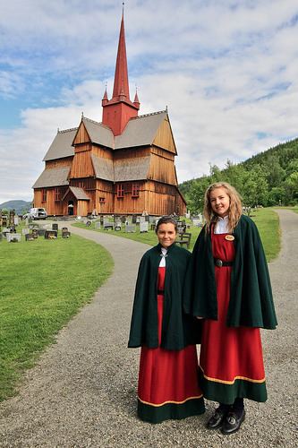
The stave church at Ringebu, built around the year 1220, is one of fewer than 30 surviving stave churches and is one of the largest.
Some 15 kilometres (9.3 mi) north of the church lies Hundorp farm, the legendary home of Dale-Gudbrand. Dale-Gudbrand is mentioned in the Heimskringla (English: The Chronicle of the Kings of Norway) by Snorri Sturluson. The account of King Olaf's (A.D. 1015-1021) conversion of Dale-Gudbrand to Christianity is popularly recognized.
Geography
Ringebu is bordered to the northwest by Sør-Fron municipality, to the southwest by Gausdal, to the south by Øyer, and by Stor-Elvdal municipality in Hedmark county on the east.
The administrative center of Ringebu municipality is the village of Vålebru which is located at an elevation of 182 metres (597 ft) above sea level, but 50% of the area within the municipal borders is greater than 900 metres (3,000 ft) above sea level. From Ringebu, two mountain passes provide road access into the Østerdal; one of these is closed during the winter. Because these mountain areas reliably provide good snow conditions, the area is a popular tourist destination. Kvitfjell ski area in Ringebu was expanded to serve as a downhill venue for the 1994 Winter Olympics.
Sister cities
The following cities are twinned with Ringebu: