
Basin size 1,635 km (631 sq mi) | ||
 | ||
River mouth Rimouski, MRC of Rimouski-Neigette, Quebec0 m (0 ft) Tributaries Left:(from the confluence) Cavée stream, Chassé stream, Rigoumabe River, Little Rimouski River, Black River (Rimouski River), White river (Rimouski River), Little Touradi River, France River, Boucher River (Rimouski River), Grand Touradi River, the Grand Matinal creek, Levasseur stream, Jansen creek, Abraham casting, Nathaël casting, Beaver Creek, Deer Lake Outlet, White Creek, Morin Creek.Right:(from the confluence) Branch Lévesque, Levasseur creek, Gagnon stream, Brule River, Bois Brule River, Hot Creek Lake, Macpès River, Creek of Petit Lac Macpès, Cat River, Indian Creek, Ferree River (Ferré Lake), casting of Poirier Rapid, Brisson River (Grand Touradi River), East Rimouski River, Flat Creek Tamahagan stream. | ||
P che saumon rivi re rimouski rimouski river salmon fishing
Rimouski River is a river emtying in Rimouski, on the South shore of St. Lawrence River, in the regional county municipality (RCM) Rimouski-Neigette, in the administrative region of Bas-Saint-Laurent, in Quebec, in Canada.
Contents
- P che saumon rivi re rimouski rimouski river salmon fishing
- Fly fishing on the rimouski river
- Course
- Hydrology
- Geology
- Toponymy
- Demographics
- Natural Environment
- Protection of Land
- History
- References
From the border between New Brunswick and Quebec, the Rimouski River crosses over the unorganized territory of Lac-Huron, Quebec, as well as the municipalities of La Trinité-des-Monts, Saint-Narcisse-de-Rimouski, Saint-Valérien, Sainte-Odile-sur-Rimouski and the city of Rimouski.
Fly fishing on the rimouski river
Course
The Rimouski River has its source at an altitude of 460 metres (1,510 ft) from the Miller Lake (length: 0.7 kilometres (0.43 mi)) located in Saint-Quentin Parish, in Restigouche County, in New Brunswick, in Notre Dame Mountains. The mouth of the Miller Lake is located 64.4 kilometres (40.0 mi) Southeast of coastal Southeastern of St. Lawrence River and 3.3 kilometres (2.1 mi) East of the border of Quebec.
The Rimouski River flows over 119.2 kilometres (74.1 mi) · .
Upper Rimouski river courses (segment of 35.5 kilometres (22.1 mi))
From Miller Lake, the Rimouski river flows over:
Intermediate course of the Rimouski River (segment of 40.7 kilometres (25.3 mi))
From Rimouski Lake, Rimouski River flows mainly in the Rimouski Wildlife Reserve on:
Lower course of Rimouski river (downstream of the Ferree River confluence) (segment of 17.2 kilometres (10.7 mi))
From the confluence of the Ferree River (Ferré Lake), the Rimouski river flows over:
Lower course of Rimouski river (downstream of the Rimouski Wildlife Reserve) (segment of 25.8 kilometres (16.0 mi))
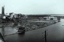
The Rimouski River pours over the long strike of the Southeast coast of St. Lawrence River up to 3.0 kilometres (1.9 mi) at low tide. This confluence is located in the harbor of Rimouski, facing the Saint-Barnabé Island. The entrance to this road is open on 1.8 kilometres (1.1 mi) between the Northeast tip of the Saint-Barnabé Island and the platform of Rimouski city. This harbor is situated at the opposite of the city of Rimouski extends to the Southwest in the harbor Saint-Barnabé.
Hydrology
The watershed of Rimouski River covert an area of 1,635 kilometres (1,015.94 mi) of which 98.6% are located in the Quebec and 1.4% in New Brunswick. The river has a Module of 30 metres (98.425 ft). The recorded maximum flow is 530 metres (1,738.845 ft) and the minimum rate is 1.6 metres (5 ft 2.992 in). It has a nivo-pluvial regime with a flood in early May and another smaller at the end of October. The river receives water from 29 streams, the main ones, from upstream to downstream, the East Rimouski River, the Grand Touradi River, the Little Touradi River and Little Rimouski River. The entire network is 2,090 kilometres (1,300 mi) streams. The basin also contains 864 lakes and 244 wetlands.
Geology
The entire river basin is part of the Appalachian. These are composed of sedimentary rock dating between 505 and 360 million years. The latter are aligned in parallel with the St. Lawrence River.
Toponymy
Rimouski appears in the act of concession of the Lordship of Rimouski, on April 24, 1968. According to Mgr Louis-François Richer Laflèche, the name comes from the Mi'kmaq "animouski" and mean "mansion of dog". The leader Abenaki Jos. Laurent ("Sozap Lolo Kizitôgw") noted in 1888 noted that Rimouski came from the Abenaqui Alemoski and means "earth of the dog". As for the popular sense of land moose statement by Father Cyprien Tanguay, he would never have been accredited. The name may refer to the presence of seals, also called "sea dogs" or "sea lions" near the mouth of the river.
Demographics
The population of the basin was 50306 person in 2007. 85% of the population lives in Rimouski, the only city in the basin.
Natural Environment
47.2% of public forests are composed of stands of conifers and 23.5% of mixed forests. In private forests, 33.3% are composed of mixed forests and 23.5% are forests of deciduouss. Forests are quite young, only 2.6% are over 120 years. About 1% of forests are cut annually.
The basin includes 31 species of fishes. The most common species are the brook trout (Salvelinus fontinalis), the chub (Semotilus atromaculatus), the pearl dace (Margariscus margarita) and the red shiner belly (Phoxinus eos). The mouth of the river is a popular venue for white peach to Smelt rainbow sky (rainbow smelt). The Atlantic salmon (Salmo salar) frequents on 29 kilometres (18 mi) downstream to breed.
Four species of mammal live in the river: the Canadian beaver (Castor canadensis), the muskrat (Ondatra zibethicus), the otter river (Lontra canadensis) and the American mink (Neovison mink). We also found there 132 species of bird, 15 spécies of amphibian and six species of reptile.
Protection of Land
The Rimouski basin includes two wildlife reserves (Rimouski and Duchénier), two controlled harvesting zones (Rivière-Rimouski and Bas-Saint-Laurent), an outfitting and a private hunting and fishing club.
As for protected areas, there are three containment areas of deer which cover 13.9% of the territory. It also meets two heronries, five habitats muskrat and four exceptional forest ecosystems.
History
The history of the basin was marked by logging. The Price Brothers and Company had a virtual monopoly of this activity. The 6, a fire of Rimouski saw mill burned down 250 houses and put more 2000 people in the street.