
Length 27 km (16.8 mi) Area 342 km² | Width 19 km (11.8 mi) Administrative subdivision Tuamotus Island group Tuamotus | |
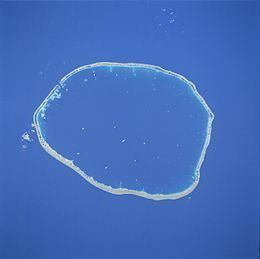 | ||
Raraka, or Te Marie, is an atoll in the west of the Tuamotu group in French Polynesia. It lies 17 km to the southeast of Kauehi Atoll.
Contents
Map of Atoll Raraka, French Polynesia
The shape of Raraka Atoll is an oval 27 km long and 19 km wide. Its fringing reef has many sandbanks and small motu. This atoll has a wide lagoon with a navigable pass to the ocean.
Raraka Atoll is now uninhabited, but it is occasionally visited by islanders from neighboring atolls. There is a village called Motupapu.
Raraka Atoll in the Tuamotus should not be confused with Raraka in Malaita, Solomon Islands 09°11′S 161°01′W.
History
The first recorded European to sight Raraka Atoll was Captain Ireland in 1831.
Raraka Atoll was visited by the historic United States Exploring Expedition, 1838-1842. Charles Wilkes reported: "The next day they reached Raraka Atoll and were allowed ashore to explore it on that and the following day. There they met about 40 peaceful islanders, who had native-born missionary among them. Their chief was missing his left hand, it having been bitten off by a shark."
Administration
Raraka Atoll belongs to the commune of Fakarava, which consists of Fakarava, as well as the atolls of Aratika, Kauehi, Niau, Raraka, Taiaro and Toau.