
Length 24 km (14.9 mi) Area 320 km² | Width 18 km (11.2 mi) Administrative subdivision Tuamotus Island group Tuamotus | |
 | ||
Dive kauehi
Kauehi, or Putake, is an atoll in the Tuamotu group in French Polynesia. The nearest land is Raraka Atoll, located 17 km to the Southeast.
Contents
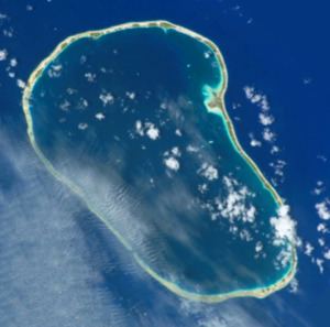
Map of Atoll Kauehi, French Polynesia
Kauehi Atoll is roughly kidney-shaped and has a wide lagoon; length 24 km, width 18 km. The atoll has a lagoon area of 320 km2 (124 sq mi), and a land area of315 km2 (122 sq mi). Kauehi's lagoon has one navigable pass.
Kauehi Atoll has 257 inhabitants as of 2012. The main village is called Tearavero.
Kauehi beach surf
History
Even though Kauehi Atoll was probably well-known to the pearl traders, the first recorded European to visit it was the Beagle's captain Robert FitzRoy in 1835.
Kauehi was later visited by the historic United States Exploring Expedition, 1838-1842. Charles Wilkes called the atoll "Vincennes" after his ship.
There is a territorial (domestic) airfield in Kauehi which was inaugurated in 2001.
Administration
Kauehi Atoll belongs to the commune of Fakarava, which consists of Fakarava, as well as the atolls of Aratika, Kauehi, Niau, Raraka, Taiaro and Toau.