
Country Languages spoken Telugu, Urdu Region Deccan Mayor Konkati Laxminarayana | ||
 | ||
Map of Ramagundam
Ramagundam is a city in the Peddapalli district of the Indian state of Telangana. It is the most populous city in the district and falls under Peddapalli revenue division. It is located on the banks of the Godavari river. As of 2011 census, the city had a population of 229,644, making it the 5th most populous in the state, with an urban agglomeration population of 242,979.
Contents
- Map of Ramagundam
- Wap4 tamilnadu express 110 ramagundam
- Etymology
- Geography
- Demographics
- Law and order
- Politics
- Economy
- Road
- Rail
- Air
- Food travelogue desh da swaad amritsar
- References
Wap4 tamilnadu express 110 ramagundam
Etymology
It gets its name from a combination of two words: (Rama + Gundam). A famous temple of the Hindu God Lord Rama is situated in the old part of the city and ‘Gundam’ means Water Springs. Ramagundam is known as city of Energy.
Geography
Ramagundam is located at 18.8000°N 79.4500°E / 18.8000; 79.4500. It has an average elevation of 179 meters (590 feet). It is about 250 Kilometers (155 mi) north east of state capital, Hyderabad, 60 km from Karimnagar And 5 km from Godavarikhani.
Demographics
As of 2011 India census, Ramagundam had a population of 229,644. Males constitute 51% of the population and females 49%. Ramagundam has an average literacy rate of 69%: male literacy is 75.3%, and female literacy is 62.4%. In Ramagundam, 8% of the population is under 6 years of age. Ramagundam is the only municipal corporation in Peddapalli district.
Law and order
Ramagundam Police Commissionerate is a city police force with primary responsibilities in law enforcement and investigation within Peddapalli, Ramagundam, Godavarikhani and Mancherial areas.
Politics
Somarapu Satyanarayana, who won as MLA in 2014 elections from Ramagundam constituency, has been appointed as Telangana's first TSRTC Public Transport Chairman in 2016.
Economy
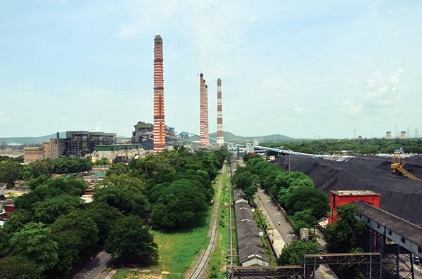
Ramagundam city is situated in the Godavari valley coalfields and has one of the India's largest thermal power stations in south region under NTPC. Mostly industries are connected with Godavarikhani- NTPC Ramagundam. Some of them are Fertilizer Corporation of India, Kesoram Cement, Basanth Nagar, National Fertilizers Limited, Engineers India Limited, TSGENCO thermal power station, Kesoram (Birla) cement factories, NTPC (RSTPS – Ramagundam Super Thermal Power Station) sourcing 2600 MW of power 24/7 and the TSSEB (Telangana State Electricity Board) unit at Ramagundam. Another 1600MW (2x800MW) is proposed as RDM-II as per expansion plan by NTPC Limited. NTPC’s first SPV or Solar photovoltaic unit of capacity 25MW (Phase-I 1x10MW, Phase-II 1x15MW) has been proposed at Ramagundam. This would help in earning carbon credits against use of solar power as renewable energy source. Also, Sripada Yellampalli project, an irrigation project, is located near Ramagundam.
Road
State Highway 1 (Telangana) is connected with Hyderabad-Karimnagar-Ramagundam Highway TSRTC operates buses and connects Ramagundam (Godavarikhani) to major parts of the state. Godavarikhani depot runs City buses in Ramagundam Corporation limits. This city is directly connected by road to capital city Hyderabad by SH 1.
Rail
Ramagundam railway station falls under the jurisdiction of Secunderabad railway division of South Central Railway zone is A+ category station and revenue generating halt.
Air
Ramagundam Airport is the airport situated in Basanthnagar of the Godavarikhani City. Its one of the oldest airport at the time of Nizam's. As its industrially developing area it has good scope to develop airport in this region by state government because of its geographical location in between 4 districts . The central government has plans to reopen the airport under UDAN scheme.