
Length 8.843 km | North end: US 95 | |
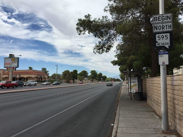 | ||
State Route 595 (SR 595) comprises a portion of Rainbow Boulevard, a north–south section line arterial in the Las Vegas Valley.
Contents
- Map of NV 595 Las Vegas NV USA
- Route description
- Rainbow Boulevard description
- History
- Major intersections
- Public transport
- References
Map of NV-595, Las Vegas, NV, USA
Route description
SR 595 begins at Tropicana Avenue and proceeds north along Rainbow Boulevard for 5.495 miles (8.843 km) to U.S. Route 95 (at the interchange locally known as the "Rainbow Curve"). The state-maintained portion of Rainbow Boulevard is a designated portion of the National Highway System.
Rainbow Boulevard description
Rainbow Boulevard begins south of Blue Diamond Road (SR 160) in Clark County and continues north to Horse Drive in northern Las Vegas. Prior to the completion of Durango Drive north of Blue Diamond Road, Rainbow Boulevard was one of only two roads west of I-15 that connected Blue Diamond road with the developed areas to the north. The other road was Industrial Road, and now Dean Martin Drive,Decatur Blvd and Fort Apache Road.
History
In January 2003, the southern terminus of SR 595 was at State Route 160 (Blue Diamond Road, Pahrump Valley Road), giving the highway a total distance of 10.846 miles (17.455 km). By January 2006, the highway had been truncated to its current terminus at Tropicana Avenue.
Major intersections
The entire route is in Clark County.
Public transport
RTC Transit Routes 101 and 219 function on this road.