
Existed: 1976 – present Length 129.4 km Major cities Las Vegas | Constructed 1976 | |
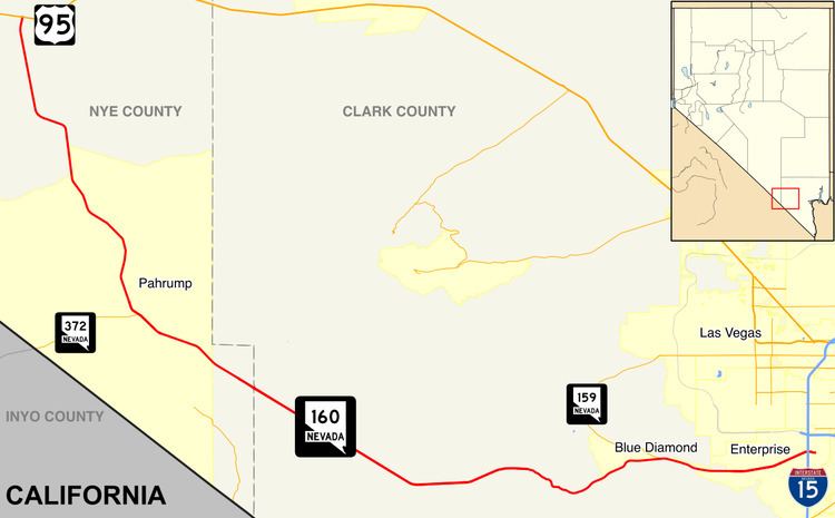 | ||
State Route 160 is a state highway in southern Nevada, United States. It connects the southern Las Vegas Valley to U.S. Route 95 northwest of the city via the Pahrump Valley. The southern part of the route sees heavy traffic, mostly due to Pahrump's continued growth as a Las Vegas bedroom community.
Contents
Map of NV-160, Nevada, USA
The route is known as Blue Diamond Road within the Las Vegas area, with the remainder referred to as the Pahrump Valley Highway.
A portion of the route was originally part of State Route 16 prior to 1978.
Route description
State Route 160 begins in the southern Las Vegas metro area at the intersection of Las Vegas Boulevard (former SR 604) and East Windmill Lane. It runs west-southwest towards the Red Rock Canyon National Conservation Area and over Mountain Springs Summit (elevation 5,502 feet (1,677 m)) before turning northwest towards Pahrump. Outside of Pahrump, SR 160 heads more north-northwest to reach its western terminus at US 95.
History
State Route 160 was originally part of State Route 16 from Pahrump north to US 95. State Route 16 was one of Nevada’s original state highways dating from the 1920s. It began at the Nevada/California border south of Pahrump and ran north to the city over Hidden Hills Ranch Road. From there, it continued north over present-day State Route 160.
In 1976, the section from Pahrump to US 95 became part of the newly created State Route 160. The section from the California border to Pahrump remained as State Route 16 until it was removed by 1982.
In 2007, State Route 160 was realigned slightly over I-15 in southern Las Vegas. The highway was moved a short distance to the south between Valley View Boulevard and Las Vegas Boulevard, realigning the southeastern terminus with East Windmill Lane at the intersection of Las Vegas Boulevard. The project also reconstructed the ramps of the aging interchange, allowing for better traffic flow to and from I-15.