
Age of rock ~1,400 years Elevation 688 m | Last eruption 29 August 2014 | |
 | ||
Similar | ||
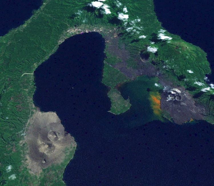
The Rabaul caldera, or Rabaul Volcano, is a large volcano on the tip of the Gazelle Peninsula in East New Britain, Papua New Guinea, and derives its name from the town of Rabaul inside the caldera. The caldera has many sub-vents, Tavurvur being the most well known for its devastating eruptions over Rabaul. The outer flanks of the highest peak, a 688-metre-high asymmetrical pyroclastic shield, are formed by thick pyroclastic flow deposits. There is no sign of a pyroclastic shield along the rim of the caldera, making the location likely underwater, on the caldera's floor.
Contents
- Map of Rabaul caldera Papua New Guinea
- Subsidiary features
- The mysterious 535 CE mega eruption
- c683 AD eruption
- 1878 eruption
- July 2010 eruptions
- 2013 14 eruptions
- AugustSeptember 2014 eruptions
- References
Map of Rabaul caldera, Papua New Guinea
Tavurvur, a stratovolcano and a sub-vent of the caldera, is the most visibly active, continuously throwing ash. In 1994 it, and nearby Vulcan, erupted and devastated Rabaul; however, due to planning for such a catastrophe, the townsfolk were prepared and only five people were killed. One of the deaths was caused by lightning, a feature of volcanic ash clouds.
In 1937, Vulcan and Tavurvur erupted simultaneously, killing 507 people. This event led to the founding of the Rabaul Volcano Observatory, which watches over the many active volcanoes on Papua New Guinea. One eruption over several days in March 2008 released a plume of ash and water vapor that drifted northwest over the Bismarck Sea.
Subsidiary features
The mysterious 535 CE mega eruption
There is evidence of a large eruption at Rabaul, that may be the event recorded in chronicles of the reign of Byzantine Emperor Justinian I as ruining the climate and helping to bring on the Middle Ages. But it is not certain, as there are other possible culprits, including Ilopango in El Salvador in Central America.
c.683 AD eruption
There was a VEI force 6 eruption at Rabaul at 683 AD ± 2 years, proved by corrected radiocarbon; there is an opinion that that eruption formed the Rabaul Caldera sea-inlet.
1878 eruption
Vulcan cone was formed during a large eruption in 1878.
July 2010 eruptions
Eruptions at Rabaul's Tavurvur volcano resumed on 23 July 2010 after nearly seven months without ash emissions. As previously noted, Tavurvur was quiet between 1 January to 8 April 2010 (BGVN 35:02).
On 9 April 2010, the Rabaul Volcano Observatory (RVO) reported that deformation measurements at Rabaul caldera during the previous 3–4 months had shown an inflationary trend with a total of 4 cm of uplift. During 2–8 April seismicity was low and variable amounts of white vapor rose from Tavurvur cone.
According to RVO, Tavurvur cone erupted on 23 July 2010 after increased seismicity, likely beneath Tavurvur cone, was detected the previous day. The series began with a few small hybrid earthquakes, followed by small low-frequency earthquakes, then continuous volcanic tremor starting at 1034 on 22 July; the eruption followed at 1300 on 23 July.
The eruption began with discharge of diffuse white plumes, followed by pink-gray fumes with low ash content. A strong odor of hydrogen sulfide was noted, and a diffuse cloud rose 1 km and drifted NW. A few hours later, observers saw billowing gray clouds, accompanied by roaring and rumbling noises. Ashfall was reported in areas to the cone's NW and NNW.
RVO reported that, during 23–25 July, seismicity was variable. Ash emissions and ashfall continued in areas to the NW. Visibility remained poor in Rabaul town (3–5 km NW of Tavurvur) due to ash made airborne by the passage of moving vehicles. Ash emissions ceased on 25 July. Later that day and into 26 July only diffuse brown-tinted vapor plumes were emitted and seismicity was very low.
After the eruption of 23–25 July, GPS data showed deflation of Tavurvur cone. Seismicity was very low, and diffuse white plumes were emitted during 26–30 July.
2013-14 eruptions
The volcano smoldered from January 2013 to March 2014 before taking a break until August.
August–September 2014 eruptions
In August 2014, the volcano woke up and smoldered until it climaxed with a VEI 3 eruption.