
Mountain type Lava cone Elevation 1,750 m Parent range Emperor Range | Last eruption 2007 Mountain range Emperor Range | |
 | ||
Location Bougainville, Papua New Guinea Similar Dukono, Mount Balbi, Langila, Ulawun, Batu Tara | ||
Bold text
Map of Bagana, Papua New Guinea
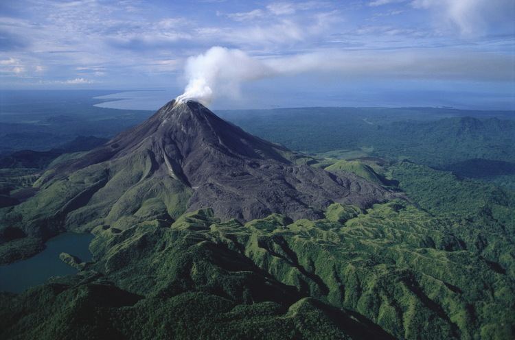
Mt Bagana is an active volcano located in the centre of the island of Bougainville, Papua New Guinea, the largest island of the Solomon group. It is the most active volcano in the country, occupying a remote portion of central Bougainville Island. One of Melanesia's youngest and most active volcanoes.
Bagana is a massive symmetrical, roughly 1750-m-high lava cone largely constructed by an accumulation of viscous andesitic lava flows. The entire lava cone could have been constructed in about 300 years at its present rate of lava production. Eruptive activity at Bagana is frequent and is characterized by non-explosive effusion of viscous lava that maintains a small lava dome in the summit crater, although explosive activity occasionally producing pyroclastic flows also occurs. Lava flows form dramatic, freshly preserved tongue-shaped lobes up to 50-m-thick with prominent levees that descend the volcano's flanks on all sides.
Just north-east of Bagana is the volcano crater lake Billy Mitchell. Bagana is one of 17 post-Miocene strato volcanos on Bougainville. U.S. General Floyd L. Parks flew over the Solomon Islands on 27 October 1948 and witnessed the eruption of Bagana. His photographs of Bagana erupting were published in Life magazine.