
Last eruption 1879 to 1880 Surface elevation 440 m Width 8 km | Area 72 km² Length 11 km | |
 | ||
Similar El Boqueron National, Coatepeque Caldera, Joya de Cerén, Museum of Art of El Salvador, San Salvador | ||
Paragliding lake ilopango
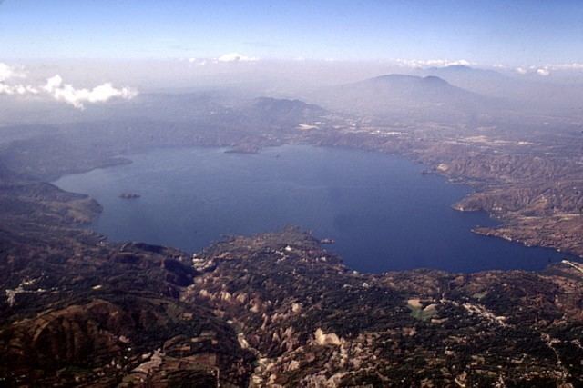
Lake Ilopango is a crater lake which fills a scenic 8 by 11 km (72 km2 or 28 sq mi) volcanic caldera in central El Salvador, on the borders of the San Salvador, La Paz, and Cuscatlán departments. The caldera, which contains the second largest lake in the country and is immediately east of the capital city, San Salvador, has a scalloped 100 m (330 ft) to 500 m (1,600 ft) high rim. Any surplus drains via the Jiboa River to the Pacific Ocean. The lake is known for being a possible source for the extreme weather events of 535–536. The military airbase, Ilopango International Airport, has annual airshows where international pilots from all over the world fly over San Salvador City and Ilopango lake.
Contents
- Paragliding lake ilopango
- Map of Lake Ilopango El Salvador
- Kayaking lake ilopango
- Eruptive historyEdit
- References
Map of Lake Ilopango, El Salvador
Kayaking lake ilopango
Eruptive historyEdit
Four major dacitic - rhyolitic eruptions occurred during the late Pleistocene and Holocene, producing pyroclastic flows and tephra that blanketed much of the country.
The caldera collapsed most recently sometime between 410 and 535 AD (based on radiocarbon dating of plant life directly related to the eruption), which produced widespread pyroclastic flows and devastated Mayan cities. The eruption produced about 25 km3 (6.0 cu mi) of tephra (20 times as much as the 1980 eruption of Mount St. Helens), thus rating a 6 on the (VEI) Volcanic Explosivity Index. The "ash-cloud fallout [..] blanketed an area of at least 10,000 square kilometres waist-deep in pumice and ash", which would have stopped all agricultural endeavor in the area for decades.
Later eruptions formed several lava domes within the lake and near its shore. The only historical eruption, which occurred from December 31, 1879, up to March 26, 1880, produced a lava dome and had a VEI of 3. The lava dome reached the surface of the lake, forming the islets known as Islas Quemadas.