
District Sankt Pölten-Land Area code 02745 Elevation 298 m Local time Thursday 9:54 PM | Time zone CET (UTC+1) Population 3,429 (1 Apr 2009) Postal code 3143 | |
 | ||
Weather 12°C, Wind S at 5 km/h, 69% Humidity | ||
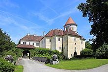
Pyhra is a town with 3286 inhabitants in the district of Sankt Pölten-Land in Lower Austria, Austria.
Contents
Map of Pyhra, Austria
Geography
Pyhra is located in the hill country of the Mostviertel in Lower Austria, near the city St. Pölten. The biggest mountain is the Amerlingkogel (628 m).
The area is 66.73 square kilometers big. 40.04 per cent of the area is wooded.
Districts
Districts are Adeldorf, Aigen, Atzling, Auern, Baumgarten, Blindorf, Brunn, Ebersreith, Egelsee, Fahra, Gattring-Raking, Getzersdorf, Heuberg, Hinterholz, Hummelberg bei Hinterholz, Kirchweg, Nützling, Oberburbach, Obergrub, Oberloitzenberg, Obertiefenbach, Perersdorf, Perschenegg, Pyhra, Reichenhag, Reichgrüben, Schauching, Schnabling, Steinbach, Unterburbach, Unterloitzenberg, Wald, Weinzettl, Wieden, Windhag, Zell and Zuleithen.
Neighbour municipalities
At the area of Pyhra border Böheimkirchen in the northeast, Kasten by Böheimkirchen and Michelbach in the east, St. Veit at the Gölsen in the south, Wilhelmsburg in the southwest and St. Pölten in the west and northwest.
Schools
Nö. Landeskindergarten, Volksschule Pyhra, Europa-Hauptschule Pyhra, Landwirtschaftliche Fachschule Pyhra and the musicschool of the Perschlingtal.