
Type Glacial Max. length 7.6 mi (12.2 km) Surface elevation 35 m Length 12.2 km | Basin countries United States Max. width 2.3 mi (3.7 km) Area 18.94 km² Mean depth 3.4 m | |
 | ||
Primary inflows Primary outflows Pushaw Stream to Penobscot River | ||
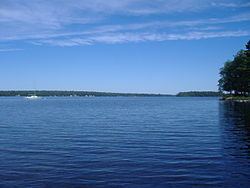
Water s edge on pushaw lake
Pushaw Lake is a lake in Penobscot County, Maine, United States about 6.5 miles (10.5 km) north of downtown Bangor and 4.5 mi (7.2 km) west of downtown Orono. The lake is part of the towns of Orono, Old Town, Hudson, and Glenburn. There are roads and private residences along much of the lake, except the southeastern side where the Caribou Bog complex borders the lake. A small dam was constructed in 1920 at the lake's outflow to maintain constant water levels.
Contents
- Water s edge on pushaw lake
- Map of Pushaw Lake Maine USA
- Dn ice boats on pushaw lake orono maine
- References
Map of Pushaw Lake, Maine, USA
Dn ice boats on pushaw lake orono maine
References
Pushaw Lake Wikipedia(Text) CC BY-SA