
Population 4,394 (2011 census) Civil parish Purley on Thames Area 4.27 km² | OS grid reference SU6676 Local time Thursday 12:45 PM | |
 | ||
Weather 19°C, Wind S at 21 km/h, 44% Humidity | ||
Purley on Thames (locally known asPurley) is a village and civil parish in Berkshire, England. Purley is centred 3 miles (4.8 km) north-west of Reading, 1 mile (1.6 km) east of Pangbourne, and 22 miles (35 km) south-east of Oxford. Consequently, the Reading urban area is the principal social, economic and cultural centre for the people of Purley. Historically, Purley comprised three separate manors and associated settlements, these being Purley Magna to the east, Purley Parva to the north-west, and Purley La Hyde, to the west.
Contents
- Map of Purley on Thames UK
- Development
- Geography
- Amenities
- Demography
- Transport
- Rail
- Bus
- River
- Government
- Early settlements
- Buildings
- Smallholdings
- Architecture
- Ecclesiastical parish priest
- References
Map of Purley on Thames, UK
Development
Purley lost most of its old houses due to emparkment around 1800 and redevelopment in the 20th century. It is bounded to the north by a stretch of the River Thames, to the east by West Reading and part of Tilehurst in Reading Borough, to the west by Pangbourne and to the south by Tilehurst and Sulham. After the sale of the estate of Purley Magna in the 1920s most of the eastern part of the parish has been developed but there is easy access to rural areas to the west and south. The area encompassing the other two manors has also retained a rural character.
Changes in the 20th century began with ribbon development along the Oxford Road and Long Lane and in recent years these properties have been redeveloped with modern housing estates. The Purley River Estate was sold off in small plots in the 1930s and for many years suffered much non-planned development. As a result of the guidance plan agreed during the 1960s it has gradually developed from self built, timber dwellings and converted railway carriages, to an area with more conventional 'everyday' houses. The gradual upgrading of the area has resulted in a diverse range of housing styles.
Geography
Previously a rural village, Purley is a suburb of Reading, though within the boundaries of West Berkshire Council. The majority of homes in Purley are detached houses, with minorities of small housing and shared ownership properties and a large council estate. The area is largely unaffordable for most of the population - as of 2016, the average price of a property in Purley is £413,268 and the median UK wage is £26,500; the average house price is thus nearly 16 times the average salary.
Due to its proximity to the River Thames, Purley has suffered severe flooding. It is not widely known that the part of Purley closest to the river has changed radically, with most properties having been built since the 1970s and, with a very few exceptions, it was a condition of planning approval that the houses were built at or above the 1947 flood level. Some builders chose to make the whole of the ground floor as garaging and other non-habitable areas with the living accommodation being on the first floor. Some gardens and roads flood on occasion but very few houses have been damaged. Homes that have been damaged by flooding are generally those whose owners have chosen to use as accommodation the non-habitable areas. The flood alleviation scheme in the form of a clay Bund and a Pumping Platform was completed by the Environment Agency in late 2014.
Amenities
Purley has two primary schools.
Purley's nearest town is Reading to which most of its homes are linked by bus or pavemented roads and its centre is within one mile from Tilehurst railway station. Sulham Woods, a site of Special Scientific Interest (SSSI) and local place of nature conservation with elevated parts, and the Thames Path National Trail beside river. These join with its main outdoor bowls green and club (in the north) and wide-pathed woods for cycling and walking (in the south) as Purley's public green spaces.
Demography
The population has around 88% White British ethnicity, 4% other white ethnicity; residents identifying with an Asian ethnicity constituted 3%, with a Caribbean or African ethnicity 1% and those with a mixed ethnicity, 2%. This differs according to the individual area within Purley; in the Sovereign social housing block, for example, 44% of children are of mixed Afro-Caribbean and White descent, with all of these children living with their non-minority, single mothers.
Transport
The linear village hub was at the edge of the flood-plain of the River Thames, where the south bank's central Reading plain narrows. Both the Reading to Oxford road (A329) and the Great Western Main Line railway are on the sloping land above the old village street, interconnected by two steep lanes crossing the railway.
Rail
Although the main line railway passes through Purley, it is mostly hidden in a deep cutting and the nearest stations are those at Tilehurst and Pangbourne.
Bus
Purley is served by Reading Buses services 16, 28, and Thames Travel services 132, 133. 142 For those with mobility problems ReadiBus provides door to door services.
River
Mapledurham Lock is close by.
Government
The civil parish of Purley on Thames stretches roughly 1.5 km both north-south and east-west and is within the area of West Berkshire Council (Unitary). It has its own Parish Council of 13 elected members with the Parish Office at Goosecroft (off Beech Road) The eastern half is almost completely redeveloped but the western half includes meadow land alongside the Thames and agricultural land on the north slope of the escarpment. There are small settlements in the extreme west (around Sulham Home Farm) and in the north west around Springs/Westbury Farms. The parish also includes Mapledurham Lock on the Thames. The parish is within the Reading West parliamentary constituency. and the South East European Constituency.
Early settlements
Purley has been settled since at least Saxon times. The original settlements were based on Purley Magna (to the east), Purley Parva (to the north-west) and Purley La Hyde (to the west). Ownership of these manors changed several times over successive centuries but the parish remained almost entirely agricultural until development began in the 20th century, with a population of 150–200. Since then it has grown to 4,232 (2001 Census) and around 5,300 people today.
Buildings
In mediaeval times the parish had three manors, Purley Magna centred on where the church is today, Purley Parva centred on Westbury Farm and Purley La Hyde centred on what is now Sulham Home Farm and Purley Hall.
A timbered Elizabethan Manor house was constructed in the 1540s, to be replaced by a brick house in 1740. This was demolished around 1800 to be replaced by the Purley Park Mansion designed by Wyatt in 1800 and on the brow of the hill to be well away from flooding. At the same time most of the eastern part of the parish was emparked; a new road (New Hill) constructed to provide access to the residual village and the Turnpike Highway diverted to the south. The Mansion House has now been converted to flats.
Purley Hall was built around 1608 to replace the manor house of Purley La Hyde and was home to personages such as Warren Hastings, Lady Baden-Powell (as a child) and Thomas Hawes (of South Sea Bubble fame)
When the Purley Park Mansion was built, the farm was moved further west and was home to the South Berks Hunt for many years. Its Master of fox hounds, Cecil Aldin, ran a Remount Depot there in World War I, employing his friend and fellow artist, Alfred Munnings as a horse doctor. After World War II the property was sold to Messrs G Percy Trentham who used it as the head offices for their civil engineering business. In the 1990s this too was redeveloped and the barn which had originally been adjacent to the church, donated to the Parish Council as a community facility.
Smallholdings
Several smallholdings were established between World War I and World War II, one by Mortimer Menpes, the artist and friend of Whistler. These have almost all now been redeveloped.
Architecture
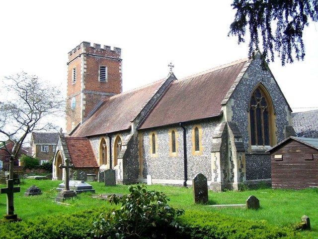
The church was described as 'ancient' in a founding charter of Reading Abbey in 1121. It is believed it was burnt down in 1135 in the Stephen/Matilda anarchy and replaced by a Norman church around 1150. The new church was built on an excavated platform and graves dating from the 10th century or 11th century were discovered in 1982 only about a foot from the surface. This church was modified and added to in the 14th and 17th centuries and completely rebuilt in 1870 in the Gothic revivalist style by G. E. Street. A further major extension was added in 1983.
Ecclesiastical parish priest
The list of rectors dates from the mid-14th century. Purley's foremost clergyman suffered ejection during the 120 years of Christian sectarian conflict commencing with Edward VI's reign. These included Richard Gatskyll, in Edward VI's reign, for being a Catholic, John Leke, in Mary I's reign, for having been married, Thomas Handcock, in 1563, for not being Protestant enough for the church overseen by Elizabeth I and Daniel Reynor, in 1662, who was a Congregationalist, and so unwilling to conform to the Act of Uniformity 1662 passed after the Restoration of Charles II.
The Church of England Rector is David Archer.