
- elevation 300 m (984 ft) Length 200 km | ||
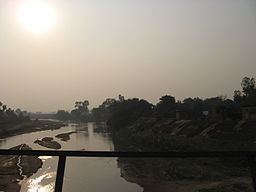 | ||
Punpun river obra bihar
The Punpun River is a tributary of the Ganges. It originates in Palamu district of Jharkhand and flows through Chatra, Aurangabad, Gaya and Patna districts of the Indian states of Jharkhand and Bihar.
Contents
- Punpun river obra bihar
- Map of Punpun River Bihar
- 2 clip punpun river in bihar flood 22 08 2016
- Course
- Tributaries
- Other features
- Religious significance
- References
Map of Punpun River, Bihar
2 clip punpun river in bihar flood 22 08 2016
Course
The Punpun originates on the Chota Nagpur Plateau, at an elevation of 300 metres (980 ft), The river mostly flows in a north-east direction and joins the Ganges at Fatuha, 25 kilometres (16 mi) downstream of Patna.
Tributaries
The main tributaries of the Punpun are – the Butane, the Madar and the Mohar.
Other features
The 200 kilometres (120 mi) long river is mostly rainfed and carries little water in the dry season. However, during rains, the Punpun often causes heavy flood damages east of Patna city. The catchment area of the Punpun is 8,530 square kilometres (3,290 sq mi). Agricultural area in the Punpun basin is about 5,000 square kilometres (1,900 sq mi). The average annual rainfall for the basin is 1,181 millimetres (46.5 in).
Religious significance
This river is mentioned in the Vayu and the Padma Puranas in connection with Gaya Mahatmya as the punah-punah (again and again) of which Pun-Pun is the colloquial form. The river might have been called by this name because it was frequently in spate. The Puranas interpret the word punah-punah in a spiritual sense that sins are removed again and again by offering oblations to forefathers in the river.