
Time zone MST (UTC+8) Website www.mbpp.gov.my | State Penang Postal code 10250, 10350, 10400 | |
 | ||
District Northeast Penang Island | ||
Pulau tikus
Pulau Tikus is a suburb northwest of George Town on Penang Island, Malaysia. Situated between George Town proper and Tanjung Tokong, this upper class suburb was named after a rock just off the coast of Penang Island. Pulau Tikus is one of the well-known places to sample Penang cuisine, as well as the home to small minorities of Eurasians, Thais and Burmese.
Contents
- Pulau tikus
- Map of Pulau Tikus 10350 George Town Penang Malaysia
- Walking in pulau tikus
- Etymology
- History
- Geography
- Landmarks
- Neighbourhoods
- Health Care
- Consulates
- References
Map of Pulau Tikus, 10350 George Town, Penang, Malaysia
Established soon after Captain Francis Light's founding of Penang Island in 1786, Pulau Tikus has been home to various cultures since the first days of British rule. The aforementioned communities have built impressive places of worship within Pulau Tikus, such as Catholic churches and Buddhist temples adorned with architectural designs of their native homelands.
In addition, a number of consulates have been established here.
Walking in pulau tikus
Etymology
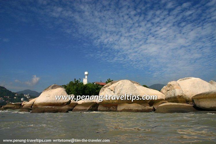
Pulau Tikus was named after the actual Tikus Island (Malay: Pulau Tikus), a rocky outcrop just 2 km off Tanjung Tokong. This particular island is shaped like a mouse and is believed to be infested with rats.
History
Pulau Tikus was first inhabited by the Eurasians, who were fleeing from persecution in Siam. The Eurasians, who were mostly Catholics, arrived at Pulau Tikus in 1811, following another group of Eurasians who had already settled within George Town in 1786. It was the Eurasians who gave the place its name, Pulau Tikus. Upon arriving, they built Kampung Serani (Eurasian Village), centred around the Church of the Immaculate Conception.
The Burmese were also among the earliest settlers at Pulau Tikus. A Burmese village, Kampung Ava, was established in the early 19th century, as well as the Dhammikarama Burmese Temple, which was built in 1803. The Thais later built two more Buddhist temples at Pulau Tikus – Wat Chayamangkalaram and Wat Buppharam.
To the southwest, James Scott, a partner of Captain Francis Light, founded the Ayer Rajah Estate. As per the usual practice at the time, Indian labourers were brought in to work in the agricultural estates; the Indian community would eventually build a handful of Hindu temples here, such as Arulmigu Balathandayuthapani Temple and Nattukkottai Chettiar Temple.
The growth of George Town over the centuries eventually swallowed up Pulau Tikus, turning it into a suburb of the city. In recent decades, urbanisation has led to the mushrooming of upmarket condominiums and commercial properties within Pulau Tikus and the vicinity of Gurney Drive.
Geography
Pulau Tikus proper starts near the junction of Burmah Road with Edgecumbe Road, and ends just before the Bagan Jermal junction. Burmah Road forms the main artery through Pulau Tikus, with the heart of the suburb at the intersection of Burmah Road with Cantonment Road.