
 | ||
Numerous proposals have been made for improvements to the Melbourne tram network, the largest such network in the world. Nearly all of these have been for track extensions of existing lines to service new areas and suburbs.
Contents
- Route 3 to Chadstone
- Route 5 to Darling station
- Route 6 to Ashburton
- Route 8 to Hartwell
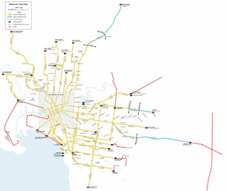
- Route 11 to Reservoir
- Route 16 to Kew Junction
- Route 19 to Gowrie Station
- Route 48 to Doncaster
- Route 48 to Fishermans Bend
- Route 57 to East Keilor
- Route 67 to Carnegie station
- Route 75 to Knox
- Route 75 to Footscray
- Route 86 to South Morang
- New North Melbourne to Richmond route
- New Port Melbourne to St Kilda route
- Route 59 Airport West to Tullamarine Airport
- References
Route 3 to Chadstone
The extension from East Malvern of route 3 was originally proposed by the Public Transport Users Association (PTUA). It would run from its current terminus to East Malvern railway station, before continuing until it reaches Chadstone Shopping Centre. It would provide Chadstone with some form of rail link, also connecting it directly to a railway station.
Route 5 to Darling station
The extension from Malvern of route 5 was originally proposed by the PTUA. It would run from its current terminus to Darling railway station and Darling Village.
Route 6 to Ashburton
In response to the State Government's 2001 Melbourne 2030 planning policy, the PTUA lobbied to extend tram route 6 from its current terminus at Glen Iris railway station to Ashburton railway station. It would require an extra 2.2 km of track extending over the Monash Freeway, continuing along High Street until reaching the level crossing.
Route 8 to Hartwell
The PTUA proposed a continuation of Route 8 from its current terminus east down Toorak Road, terminating near to where it would join the current Route 75. It would cover just over 4 km.
Route 11 to Reservoir
The City of Darebin and the PTUA have been campaigning for the extension of route 11 to the Reservoir activity centre. The most likely route would be to continue north along Gilbert Road reaching Edwardes Lake, before turning right into Edwardes Street and continuing east to a new terminus near Reservoir railway station in the commercial area. The extension would cover a distance of just over 3 km.
An alternative, which appeared in Darebin's 2010 proposal, has the tram heading north on Gilbert Rd, east on Henty St, north on Spratling St, then east on Edwardes Rd to the terminus. This route avoids the steep grade around Edwardes Lake.
The cost was estimated to be $30 million, with $50,000 required for a feasibility study. The State Government has made no commitment to investigate or build the extension.
Route 16 to Kew Junction
The PTUA proposed extending the route of Route 16 with the tram continuing left at the corner of Cotham and Glenferrie Roads, following the current Route 109 for 800m to the west before terminating at the Kew Junction. This would allow interchange with Route 48 trams and the 200 and 207 buses via Johnston Street. Little infrastructure would be required, as the tracks are already in place.
Route 19 to Gowrie Station
In the lead up to the 2014 State election the Greens proposed extending route 19 from its current terminus at Bakers Road, North Coburg for a length of 3.7 km passing Merlynston Station, Fawkner Station and ending with a new terminus outside Gowrie Station.
Route 48 to Doncaster
The PTUA, City of Boroondara, City of Manningham and City of Yarra have been advocating for an extension of the route. It has been seen as a cheaper and more efficient alternative to the heavily advocated Doncaster railway line, and an option to finally bring rail to Manningham, which is the only metropolitan municipality without a rail service.
The 4-kilometre extension would be a continuation of the route along Doncaster Road past Greythorn Village, Doncaster Park and Ride with a terminus at Westfield Doncaster or possibly the mc2 community facility in Doncaster Hill.
The extension was first proposed in the mid-1940s, soon after the tram route was extended to its present-day terminus at Balwyn Road. The then-City of Camberwell made the proposal formally to the Tramways Board in 1945, but the project was not pursued.
In 2006, the Liberal opposition under Ted Baillieu promised the extension by 1 July 2010 if he was to win office in the next election, pricing it at $35 million. It was stated that there would have been about 2 accessible stops every kilometre, similar to the recent Box Hill tram extension. The Labor Government held onto power, and the extension was not built, even when the Liberals later won office in 2010.
A study commissioned by Manningham Council argued that the steep gradient on Doncaster Road would preclude current rolling stock from operating safely on Doncaster Road. The report also suggested that extra trams would need to be purchased to address the issue. The report was never released, but the PTUA and other groups criticsed its public findings, contending that steeper gradients are present across the existing network, such as Burke Road in Camberwell and along the Burwood Highway. Both major parties have since failed to commit to an extension.
Route 48 to Fishermans Bend
State and local governments have also proposed the extension of Route 48 from its current terminus at Victoria Harbour in Docklands across the Yarra River and into the Fishermans Bend precinct, a future major urban renewal area. It would require the construction of a new tram-only bridge and generally follow the path of Fennell and Plummer Streets. The tram extension is proposed as an interim solution to connect Fishermans Bend residents to the CBD via mass transit until the metropolitan railway network can be extended with new underground stations.
The proposed bridge has faced some opposition from local groups and residents, whom fear it will destroy a local park and prevent tall boats from mooring at a nearby marina and travelling upstream. The bridge has been costed by the State Government at over $200 million.
Route 57 to East Keilor
In the lead up to the 2014 State election the Greens proposed extending Route 57 for 5.5 km from its current terminus in Maribyrnong along Canning Street and Milleara Road before reaching a new terminus at the Keilor East shopping precinct.
Route 67 to Carnegie station
The PTUA proposed a continuation of Route 67 from its current terminus north up Koornang Road, terminating at Carnegie railway station and passing through Carnegie shopping strip. It would cover just 900 metres and become a major mode interchange.
Route 75 to Knox
In the lead up to the 2014 State election the Greens proposed extending route 75 from its current terminus outside Vermont South Shopping Centre for a length of 6.8 km down Burwood Highway passing Westfield Knox City Shopping Centre and ending near to Knox City Council precinct.
Route 75 to Footscray
Melbourne and Maribyrnong City Councils have been advocating for a new tram link between the CBD and Footscray. The commonly cited route would be to extend Route 75 tram tracks from their current terminus near Harbour Town in Docklands along the median of Footscray Road, acting as a light rail with minimal stops, before crossing the Maribyrnong River into Napier Street. From here it is possible the tram could terminate at Footscray railway station by turning right at Hyde Street, or possibly following Whitehall and Hopkins Streets to rejoin Route 82 as one long route.
Route 86 to South Morang
Whittlesea transport activists are determined to put the extension of route 86 to South Morang on the agenda by gaining support and signatures. The City of Whittlesea's Future Transport Plan also clearly outlines that they see the extension as an important development in their future. The current terminus which is at the junction on Plenty and McKimmies roads out the front of Bundoora's RMIT Campus would be extended along Plenty Road to Bush Boulevard where it would turn North-West towards the Plenty Valley Shopping Hub, along McDonald's Road to the recently extended South Morang station. From this point it has been discussed and outlined in the City of Whittlesea's Future Transport Plan that the route would continue north along Ferres Boulevard past the Whittlesea Council buildings and along The Lakes Boulevard back towards Plenty Road.
New North Melbourne to Richmond route
Leading up to the Australian federal election, 2013, the Australian Greens proposed the creation of a new east–west route between North Richmond and North Melbourne railway stations. It would travel along Victoria Street/Parade for most of its route, before diverting south in the west to terminate in front of North Melbourne station. Most of the route is currently used for other routes, such as route 109 between St Vincents Plaza and North Richmond Station and route 57 between Errol Street and Elizabeth Street. Tram tracks currently exist on some sections of Victoria St, but are unused and in disrepair. The route was costed at $28.5 million, with the Greens promising $15 million of federal funding. The figure was estimated using costs and distances from the Box Hill tram extension of 2002.
New Port Melbourne to St Kilda route
A 5 kilometre tram link between St Kilda and Port Melbourne along Beaconsfield Parade was first proposed in 2004, subsequently promoted by the City of Port Phillip in 2005 and backed by Tourism Victoria. A 2007 feasibility study into the route found that the high density population could sustain around 200,000 annual commuter trips and that a "shuttle tram" between the two bayside suburbs would be financially viable if patrons were charged $6 per one-way trip. Proponents cite the wide median reservation and ample roadspace available to reduce project costs as well as high patronage levels of light rail in the area. To address residents concerns over possible loss of beachfront views, the Council investigated the possibility of a new high-tech line, involving wire-free operation. Critics argued that it would be duplicating the 12 tram route, with the two routes running in parallel just 200 metres apart for about 2 kilometres along Beaconsfield Parade. However, a direct tram journey between St Kilda and Port Melbourne is not possible and currently requires a change of routes at Southbank, which is a 20-kilometre round trip.
Route 59 Airport West to Tullamarine Airport
5.5 km route extension along Melrose Drive to the airport.