Neha Patil (Editor)

Prairie River (Michigan)

Updated on
Edit
Like
Comment
Share on FacebookTweet on TwitterShare on LinkedInShare on Reddit
Main source
  
Mouth
  
Length
  
87 km

Country
  
United States of America

Prairie River (Michigan) httpsuploadwikimediaorgwikipediacommonsthu

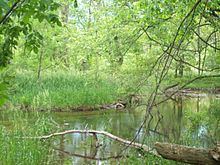
The Prairie River is a small river that flows 54 miles (87 km) through Branch and St. Joseph counties in Michigan. The river rises at 41°48′20″N 85°00′54″W in northern Kinderhook Township in Branch County, and flows west-northwest into the St. Joseph River at 41°54′45″N 85°38′21″W just south of the city of Three Rivers, Michigan.

Contents

Map of Prairie River, Michigan, USA

Drainage basin

The Prairie River drains all or portions of the following:

  • Branch County, Michigan
  • Bethel Township
  • Bronson Township
  • Gilead Township
  • Kinderhook Township
  • Noble Township
  • Ovid Township
  • St. Joseph County
  • Burr Oak Township
  • Colon Township
  • Fawn River Township
  • Lockport Township
  • Nottawa Township
  • Sherman Township
  • Steuben County, Indiana
  • Jamestown Township
  • Millgrove Township
  • Tributaries

    (from the mouth)

  • (right) Spring Creek
  • Nottawa Ditch
  • Colon Ditch
  • Washburn Lake
  • Beaver Drain
  • Beaver Lake
  • Lake Templene is formed by an impoundment on the river
  • (right) outflow from Bryant Lake
  • (left) outflow from Perrin Lake
  • Prairie River Lake, a natural lake on the river
  • (left) outflow from Fish Lake
  • outflow from Hawkins Lake
  • outflow from Eight Foot Lake
  • outflow from Grey Lake
  • outflow from Omena Lake
  • (left) Stewart Lake Drain
  • Stewart Lake
  • (left) outflow from Lake Pleasant
  • outflow from Lake Michiana (Hog Lake)
  • (left) outflow from Dragon Lake,
  • References

    Prairie River (Michigan) Wikipedia


    Similar Topics