
Population 1,340 Sovereign state United Kingdom | OS grid reference TL017089 Post town BERKHAMSTED Local time Saturday 8:42 AM Dialling code 01442 | |
 | ||
Weather 5°C, Wind NE at 16 km/h, 82% Humidity | ||
Lucy marc s wedding at potten end church boxmoor lodge hotel hemel hempstead hertfordshire
Potten End is a village in west Hertfordshire, England. It is located in the Chiltern Hills, two miles east-north-east of Berkhamsted, three miles north west of Hemel Hempstead and two miles south east of the National Trust estate of Ashridge. Nearby villages include Nettleden, Great Gaddesden and the hamlet of Frithsden. The joint Parish Council for Nettleden with Potten End CP (where the 2011 Census population was included) administers under Dacorum Borough Council.
Contents
- Lucy marc s wedding at potten end church boxmoor lodge hotel hemel hempstead hertfordshire
- Map of Potten End Berkhamsted UK
- Open Day
- Places of Worship
- References
Map of Potten End, Berkhamsted, UK
The parish of Potten End was formed in 1894.
The village name derives from the earlier form "Pottern" which refers to a place where pots and pottery were made. "End" is an old term common in Hertfordshire defining any outlying settlement in a far corner of a parish or manor.
At the centre of the village there is a Green and pond. The village largely comprises residential properties, together with Holy Trinity Church; a primary/junior school Potten End First School; a village shop; and two public houses, Martin's Pond and The Plough. A number of small businesses are also based in the village. Recreational facilities include cricket and football fields, bowls club and a children's grassed play area. A Village Hall provides community use for a wide variety of regular and special events.
There has been only minimal building development in the village in recent years and no immediate prospect of the surrounding farming land being given over to residential expansion. The Parish Council are keen to retain this status quo but are concerned that eventually the green belt will be lost by the growth of Hemel Hempstead where the gap is now down to little more than a mile from the boundary at Hempstead Lane.
The geography of Potten End is such that most of the village is situated on a plateau of land extending from Ashridge to the north and rising from the valleys of the River Gade to the east and from the River Bulbourne to the west. The Green lies at a height of 172 m (565 ft) above mean sea level. Consequently, all roads from Potten End lead downhill, some of which can be difficult to negotiate after snowfall.
Live Potten End weather information is available on the Potten End Weather web site.
The long distance county footpath The Hertfordshire Way passes on the west side of the village.
Public transport to/from the village comprises an infrequent bus service (to Hemel Hempstead & to Berkhamsted) of five return trips a day. The nearest rail link is at Berkhamsted station, 2 miles distant.
Following his retirement from professional cricket Fred Titmus and his wife Stephanie ran the post office and newsagent's shop in the village for 20 years. Subsequently this facility transferred to the village shop but following a review by the Post Office, the sub post office counter was removed in 2008 despite a strenuous campaign to save it by the village and local MP.
Open Day
Every two years on the last Sunday in June, the village hosts an Open Day, with special outdoor events and a number of private gardens open to the public. The last such event was held on 26 June 2011.
Places of Worship
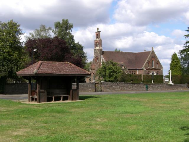
The Anglican church of Holy Trinity was consecrated in 1868 and for its first thirty years operated as a Chapel of Ease to Berkhamsted St. Peter, before becoming the church of the newly created ecclesiastical parish of Potten End. In recent years the church has reformed links with St. Peter as part of the Berkhamsted Team Ministry. The parish lies within the Church of England Diocese of St. Albans. The church has a graveyard within its boundaries and in 2006 an additional Parish Burial Ground was consecrated on an area of land down Hempstead Lane. The monthly church newsletter is delivered to every household in the village and includes local news and articles, council reports and historical items from the 'Potten End Archivist'.
A small baptist chapel (with small graveyard) also existed. This was on a site set back from the general frontage of properties on The Front. The chapel was closed and the building sold in 1997 and is now a private residence.