
Time zone CET/CEST (UTC+1/+2) Area 5.53 km² Population 480 (31 Dec 2008) Dialling code 034496 | Elevation 244-314 m (−790 ft) Postal codes 04626 Local time Saturday 5:02 AM Postal code 04626 Municipal assoc. Oberes Sprottental | |
 | ||
Weather 1°C, Wind S at 5 km/h, 89% Humidity | ||
Posterstein is a German municipality in the Thuringian Landkreis of Altenburger Land.
Contents
- Map of Posterstein Germany
- Neighboring municipalities
- Municipal arrangement
- History
- Culture and landmarks
- Business and transportation
- References
Map of Posterstein, Germany
Neighboring municipalities
Municipalities near Posterstein are Heukewalde, Löbichau, Nöbdenitz, and Vollmershain in the district of Altenburger Land; as well as Paitzdorf and the city of Ronneburg in the district of Greiz.
Municipal arrangement
Stolzenberg is Posterstein's only subdivision.
History
Within the German Empire (1871–1918), Posterstein was part of the Duchy of Saxe-Altenburg.
Culture and landmarks
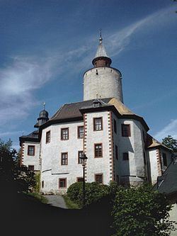
The Postersteiner Burg, which is lit up at night, is the most important building in the town. It is also visible north of the community from the Bundesautobahn 4.
Business and transportation
The next train station on the rail line from Posterstein is in Nöbdenitz.
References
Posterstein Wikipedia(Text) CC BY-SA