
Land area 4,200 acres (17 km) Vessel arrivals 230 (CY 2014) Opened 1932 | Available berths 14 Value of cargo 1.5 billion USD (CY 2014) | |
 | ||
Annual cargo tonnage 4.1 million metric revenue tons (CY 2014) | ||
Port of stockton wins steamboat race in sacramento california hd stock footage
The Port of Stockton is a major inland deepwater port in Stockton, California located on the San Joaquin River before it joins the Sacramento River to empty into Suisun Bay, eighty miles inland. The port sits on about 4,200 acres (17 km2), and occupies an island in the Sacramento–San Joaquin River Delta, and a portion of a neighborhood known as Boggs Tract. It is governed by a commission appointed by the City of Stockton and San Joaquin County. The Port of Stockton is California's third largest port after Port of Los Angeles and Port of Long Beach. In 2012 it supported 4,500 jobs and made about $4.9 million in local tax funds.
Contents
- Port of stockton wins steamboat race in sacramento california hd stock footage
- Map of Port of Stockton Stockton CA 95203 USA
- Geography
- Early years
- 1930s1950s
- 1960s1990s
- 2000 to present
- Port services
- References
Map of Port of Stockton, Stockton, CA 95203, USA
Geography
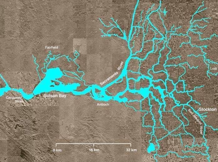
The only natural outlet for the waters of the Central Valley to pass into the sea is through the narrow Carquinez Strait, at the inland eastern extreme of San Pablo Bay. Further inland are Suisun and Grizzly Bays, arms of the Pacific Ocean deep in the Californian interior. Further inland again from these last bays is the broad Sacramento–San Joaquin River Delta, formed where the San Joaquin and Sacramento Rivers meet and cross together. This verdant triangle of land with deep black soils is at the heart of the Central Valley and stretches some fifty miles from Suisun Bay on the west to the cities of Stockton and Sacramento on the east.
Early years
In 1846, the first cargo boat ascended the San Joaquin River. In 1848, John Doak established the first ferry service on the river, and the first freight vessel, the sloop Maria, visited Stockton. In 1849, Doak brought lumber from San Francisco to Stockton and began a lumber business. By the 1850s, the port had become a center of commodity shipping and the supply center for the goldfields. By the 1860s, the region saw a decline in gold production and an increase in agriculture.
1930s–1950s
The first dredging contracts for the Stockton Deepwater Channel were awarded in 1930. The Port District officially opened on February 2, 1933 when the Daisy Grey arrived bringing lumber from Oregon.
1960s–1990s
Port management recognized the increasing importance of containerized cargo and upgraded dock side facilities. The ship channel was improved dramatically in order to accommodate large PANAMAX class ships.
2000 to present
The Navy Ruff and Ready Island Naval Supply Depot built during World War II was phased out of use as a result of special legislation sponsored by Senator Dianne Feinstein in 1995. It was transferred to the port between 2000 and 2003. This area of the port is now known as the "West Complex".