
Opening date 1977 Width (base) 56 feet Construction cost 13.1 million USD | Height unlimited Length 122 m | |
 | ||
Official name Port Mayaca Lock and Dam Location Canal Point, Florida, United States | ||
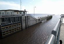
The Port Mayaca Lock is a navigable lock and dam on the Okeechobee Waterway (St. Lucie Canal), adjacent to U.S. Route 441 and U.S. Route 98 at Canal Point, in Martin County, Florida, United States.
Contents
It is located near Port Mayaca at latitude 26° 59" 5', longitude -80° 37" 5'.
Port Mayaca Lock is open daily from 7:00am to 5:00pm. New Lock hour as of 1 April 2015.
The total cost of construction was $13.1 million.
PurposeEdit
This structure was created to help raise the water level in the lake, for the purpose of retaining fresh water for agricultural use, city water supply, and for navigation. It also serves for regulating flood control water into the Everglades during hurricane season.
Technical informationEdit
The lock chamber is 56 feet (17 m) wide by 400 feet (120 m) long, and 14 feet (4.3 m) deep. The lift distance between the St. Lucie Canal and Lake Okeechobee is normally 1/2 to 2 feet (0.61 m). The channel width is 100 feet (30 m), and 8 feet (2.4 m) deep.
The lock gates are "sector gates" (pie-slice shaped), and are made of steel. The spillway is ogee-type concrete, with 4 vertical lift gates.
The discharge capacity is 14,800 cubic feet per second (420 m3/s).
Radio channelEdit
This lock operates on Marine VHF radio channel 13.