
Surface area 175 acres (0.71 km) Area 71 ha | Primary inflows Basin countries United States Surface elevation 62 m Inflow source Ramapo River | |
 | ||
Drive new jersey wanaque to pompton lakes to wayne side streets
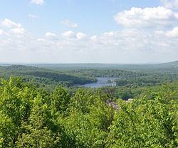
Pompton Lake is a 175-acre man-made lake on the Ramapo River which is located within the towns of Pompton Lakes and Wayne in Passaic County, New Jersey. The lake was formed by the construction of the Pompton Lake Dam in 1908 after a prior wooden dam was destroyed by a flood in 1903. The waters impounded in the lake serve as a supplemental drinking source. It is primarily fed by the Ramapo River, but also receives inflow from Acid Brook and smaller tributaries. The Ramapo River continues downstream of Pompton Lake Dam, flowing into the Pompton River and ultimately the Passaic River. The area of the Pompton Lake watershed is 176 square miles.
Contents
- Drive new jersey wanaque to pompton lakes to wayne side streets
- Map of Pompton Lake New Jersey USA
- Pompton lakes nj cancer cluster town by itownsee com
- References
Map of Pompton Lake, New Jersey, USA
Pompton lakes nj cancer cluster town by itownsee com
References
Pompton Lake Wikipedia(Text) CC BY-SA