
Founded 7 February 1837 | Area 510.5 km² Population 505,672 (2013) | |
 | ||
Website www.passaiccountynj.org Colleges and Universities Passaic County Communi, William Paterson University, Montclair State University, Berkeley College, Dover Business College Points of interest Great Falls, Lambert Castle, Garret Mountain Reservation, Paterson Museum, Yogi Berra Museum and Lear | ||
Passaic County (/pəˈseɪ.ᵻk/ pə-SAY-ik, locally /pəˈseɪk/ pə-SAYK) is a county in the U.S. state of New Jersey that is part of the New York metropolitan area.
Contents
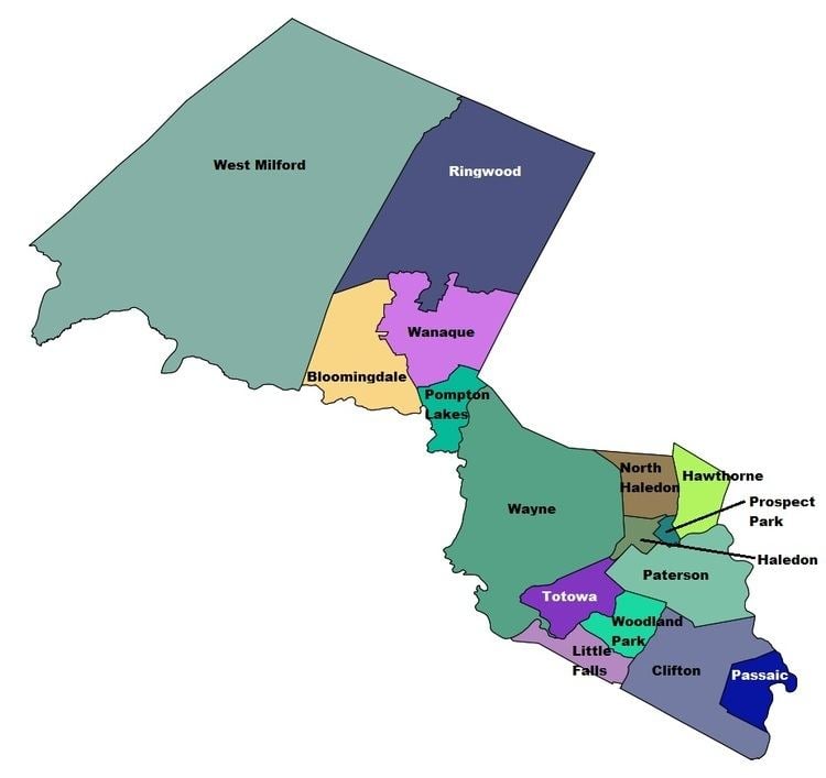
- Map of Passaic County NJ USA
- Geography
- 2010 Census
- 2000 Census
- Law and government
- Highlands protection
- Politics
- Municipalities
- Roads and highways
- Public transportation
- Education
- Media
- Points of interest
- Climate and weather
- References
Map of Passaic County, NJ, USA
As of the 2010 Census, the population was 501,226, an increase of 12,177 (+2.5%) from the 489,049 counted in the 2000 Census, As of the 2016 Census estimate, the county's population was 507,945, making it the state's ninth-most populous county, and marking an increase of 1.3% from 2010. Its county seat is Paterson. The most populous place was Paterson, with 146,199 residents at the time of the 2010 Census, more than 29% of the county's population, while West Milford, covered 80.32 square miles (208.0 km2), the largest total area of any municipality, more than 40% of the county's area.
Passaic County was created on February 7, 1837, from portions of Bergen County and Essex County.
Geography
The highest point is any one of six areas on Bearfort Ridge in West Milford at approximately 1,480 feet (450 m) above sea level. The lowest elevation is approximately 20 feet (6.1 m) along the Passaic River in Clifton.
The southeastern, more populous half of the county is either flat near the river or mildly hilly. The northwestern section is rugged and mountainous.
According to the 2010 Census, the county had a total area of 197.10 square miles (510.5 km2), including 184.59 square miles (478.1 km2) of land (93.7%) and 12.51 square miles (32.4 km2) of water (6.35%).
2010 Census
The 2010 United States Census counted 501,226 people, 166,785 households, and 120,919 families residing in the county. The population density was 2,715.3 per square mile (1,048.4/km2). The county contained 175,966 housing units at an average density of 953.3 per square mile (368.1/km2). The racial makeup of the county was 62.65% (314,001) White, 12.83% (64,295) Black or African American, 0.67% (3,348) Native American, 5.01% (25,092) Asian, 0.03% (156) Pacific Islander, 15.11% (75,735) from other races, and 3.71% (18,599) from two or more races. Hispanics or Latinos of any race were 37.04% (185,677) of the population.
Out of a total of 166,785 households, 34.5% had children under the age of 18 living with them, 48.7% were married couples living together, 17.5% had a female householder with no husband present, and 27.5% were non-families. 22.6% of all households were made up of individuals, and 9.4% had someone living alone who was 65 years of age or older. The average household size was 2.94 and the average family size was 3.45.
In the county, 24.9% of the population were under the age of 18, 10.3% from 18 to 24, 27.1% from 25 to 44, 25.7% from 45 to 64, and 12% who were 65 years of age or older. The median age was 36.1 years. For every 100 females the census counted 94.2 males, but for 100 females at least 18 years old, it was 91.1 males.
Same-sex couples headed one in 149 households in 2010.
2000 Census
As of the 2000 United States Census there were 489,049 people, 163,856 households, and 119,614 families residing in the county. The population density was 2,639 people per square mile (1,019/km²). There were 170,048 housing units at an average density of 918 per square mile (354/km²). The racial makeup of the county was 62.32% White, 13.22% Black or African American, 0.44% Native American, 3.69% Asian, 0.04% Pacific Islander, 16.24% from other races, and 4.05% from two or more races. 29.95% of the population were Hispanic or Latino of any race. Among those who reported their ancestry, 16.6% were of Italian, 9.5% Irish, 8.1% German and 6.2% Polish ancestry according to Census 2000.
There were 163,856 households out of which 35.60% had children under the age of 18 living with them, 51.50% were married couples living together, 16.00% had a female householder with no husband present, and 27.00% were non-families. 22.20% of all households were made up of individuals and 9.50% had someone living alone who was 65 years of age or older. The average household size was 2.92 and the average family size was 3.42.
In the county, the population was spread out with 26.10% under the age of 18, 9.30% from 18 to 24, 31.30% from 25 to 44, 21.30% from 45 to 64, and 12.10% who were 65 years of age or older. The median age was 35 years. For every 100 females there were 94.00 males. For every 100 females age 18 and over, there were 90.80 males.
The median income for a household in the county was $49,210, and the median income for a family was $56,054. Males had a median income of $38,740 versus $29,954 for females. The per capita income for the county was $21,370. About 9.40% of families and 12.30% of the population were below the poverty line, including 17.30% of those under age 18 and 9.20% of those age 65 or over.
Law and government
The Passaic County Court House and Administrative Building complex is located at the county seat in Paterson.
In Passaic County's commission form of government, the Board of Chosen Freeholders discharge both executive and legislative responsibilities. Seven Freeholders are elected at-large for three-year terms on a staggered basis. A Freeholder Director and Freeholder Deputy Director are elected from among the seven Freeholders at an annual reorganization meeting in January. The Freeholders select a County Administrator who, in the role of chief administrative officer, supervises the day-to-day operation of county government and its departments.
Passaic County operates through six standing committees of the Board of Chosen Freeholders. They are Administration & Finance; Health, Education and Community Affairs; Public Works and Buildings & Grounds; Law & Public Safety; Human Services and Planning and Economic Development. The Freeholders also appoint individuals to departments, agencies, boards and commissions for the effective administration of county government.
As of 2015, Passaic County's Freeholders are:
Constitutional officers elected on a countywide basis are:
Passaic County constitutes Vicinage 11 of the New Jersey Superior Court. Vicinage 11 is seated at the Passaic County Courthouse in Paterson; the Assignment Judge for Vicinage 11 is the Honorable Ernest M. Caposela. Law enforcement at the county level is provided by the Passaic County Sheriff and the Passaic County Prosecutor's Office.
Three federal Congressional Districts cover the county, with most of the northern portion of the county in the 5th District, most of the southern portion of the county in the 9th District and the central portion of the county in the 11th District. New Jersey's Fifth Congressional District is represented by Josh Gottheimer (D, Wyckoff). New Jersey's Ninth Congressional District is represented by Bill Pascrell (D, Paterson). New Jersey's Eleventh Congressional District is represented by Rodney Frelinghuysen (R, Harding Township).
The county is part of the 26th, 34th, 35th, 36th, 38th, 39th and 40th Districts in the New Jersey Legislature. For the 2016–2017 session (Senate, General Assembly), the 26th Legislative District of the New Jersey Legislature is represented in the State Senate by Joseph Pennacchio (R, Montville) and in the General Assembly by BettyLou DeCroce (R, Parsippany-Troy Hills) and Jay Webber (R, Morris Plains). For the 2016–2017 session (Senate, General Assembly), the 34th Legislative District of the New Jersey Legislature is represented in the State Senate by Nia Gill (D, Montclair) and in the General Assembly by Thomas P. Giblin (D, Montclair) and Sheila Oliver (D, East Orange). For the 2016–2017 session (Senate, General Assembly), the 35th Legislative District of the New Jersey Legislature is represented in the State Senate by Nellie Pou (D, North Haledon) and in the General Assembly by Shavonda E. Sumter (D, Paterson) and Benjie E. Wimberly (D, Paterson). For the 2016–2017 session (Senate, General Assembly), the 36th Legislative District of the New Jersey Legislature is represented in the State Senate by Paul Sarlo (D, Wood-Ridge) and in the General Assembly by Marlene Caride (D, Ridgefield) and Gary Schaer (D, Passaic). For the 2016–2017 session (Senate, General Assembly), the 38th Legislative District of the New Jersey Legislature is represented in the State Senate by Robert M. Gordon (D, Fair Lawn) and in the General Assembly by Tim Eustace (D, Maywood) and Joseph Lagana (D, Paramus). For the 2016–2017 session (Senate, General Assembly), the 39th Legislative District of the New Jersey Legislature is represented in the State Senate by Gerald Cardinale (R, Demarest) and in the General Assembly by Holly Schepisi (R, River Vale) and Robert Auth (R, Old Tappan). For the 2016–2017 session (Senate, General Assembly), the 40th Legislative District of the New Jersey Legislature is represented in the State Senate by Kevin J. O'Toole (R, Cedar Grove) and in the General Assembly by David C. Russo (R, Ridgewood) and Kevin J. Rooney (R, Wyckoff). Rooney was sworn into office on December 12, 2016, to fill the seat of Scott Rumana, who had resigned from office on October 20, 2016, to become a judge of the New Jersey Superior Court.
Highlands protection
In 2004, the New Jersey Legislature passed the Highlands Water Protection and Planning Act, which regulates the New Jersey Highlands region. The northwestern area of the county, comprising the municipalities of Bloomingdale, Pompton Lakes, Ringwood, Wanaque and West Milford, was included in the highlands preservation area and is subject to the rules of the act and the Highlands Water Protection and Planning Council, a division of the New Jersey Department of Environmental Protection. Some of the territory in the protected region is classified as being in the highlands preservation area, and thus subject to additional rules.
Politics
As of March 23, 2011, there were a total of 266,617 registered voters in Passaic County, of which 82,529 (31.0%) were registered as Democrats, 49,852 (18.7%) were registered as Republicans and 134,152 (50.3%) were registered as Unaffiliated. There were 84 voters registered to other parties. Among the county's 2010 Census population, 53.2% (vs. 53.2% in Passaic County) were registered to vote, including 70.8% of those ages 18 and over (vs. 70.8% countywide).
In the 2008 presidential election, Democrat Barack Obama received 58.8% of the vote here (113,257 cast), ahead of Republican John McCain with 37.7% (72,552 votes) and other candidates with 0.8% (1,586 votes), among the 192,558 ballots cast by the county's 273,483 registered voters, for a turnout of 70.4%. In the 2004 presidential election, Democrat John Kerry received 53.9% of the vote here (94,962 ballots cast), outpolling Republican George W. Bush with 42.7% (75,200 votes) and other candidates with 0.5% (1,149 votes), among the 176,303 ballots cast by the county's 254,569 registered voters, for a turnout percentage of 69.3.
In the 2009 gubernatorial election, Democrat Jon Corzine received 50.8% of the vote here (57,010 ballots cast), ahead of Republican Chris Christie with 43.2% (48,500 votes), Independent Chris Daggett with 3.8% (4,288 votes) and other candidates with 0.9% (981 votes), among the 112,278 ballots cast by the county's 262,723 registered voters, yielding a 42.7% turnout.
Municipalities
Municipalities in Passaic County (with 2010 Census data for population, housing units and area in square miles) are: Other, unincorporated communities in the county are listed next to their parent municipality. Most of these areas are census-designated places (CDPs) that have been created by the United States Census Bureau for enumeration purposes within a Township. Other communities and enclaves that exist within a municipality are also listed next to the name.
Roads and highways
As of 2010, the county had a total of 1,320.70 miles (2,125.46 km) of roadways, of which 1,024.41 miles (1,648.63 km) are maintained by the municipality, 237.45 miles (382.14 km) by Passaic County and 54.34 miles (87.45 km) by the New Jersey Department of Transportation and 4.50 miles (7.24 km) by the New Jersey Turnpike Authority.
The major highways that travel through Passaic County are Interstate 287, Interstate 80, U.S. Route 202, U.S. Route 46, Route 23, Route 21, Route 20, Route 19, Route 4, Route 3, and the Garden State Parkway. The parkway crosses the county in Clifton, connecting Bloomfield in Essex County to the south to Elmwood Park in Bergen County in the north. Parkway interchanges 153 (signed for Route 3 and Route 46 West) / 153A (for Route 3 East) / 153B (for Route 3 and Route 46 West), 154 (for Route 46), 155 (for Clifton) / 155P (for Clifton / Paterson) and 156 (to Route 46).
Public transportation
NJ Transit's Main Line serves the eastern part of Passaic County, with station stops at Hawthorne, Paterson, Clifton, Passaic and Delawanna. Numerous New Jersey Transit bus routes serve Passaic County as well.
Education
Media
Passaic County is served by New York City-based commercial television & radio stations and New Jersey Network public television.
Points of interest
Climate and weather
In recent years, average temperatures in the county seat of Paterson have ranged from a low of 19 °F (−7 °C) in January to a high of 86 °F (30 °C) in July, although a record low of −11 °F (−24 °C) was recorded in January 1961 and a record high of 105 °F (41 °C) was recorded in September 1953. Average monthly precipitation ranged from 2.86 inches (73 mm) in February to 4.78 inches (121 mm) in September.