
Area rank Ranked 6th Postal code 36000-38999 Area 28,800 km² | Time zone EET (UTC+2) Area code +380-53 ISO 3166 code ISO 3166-2:UA | |
 | ||
Clubs and Teams FC Vorskla Poltava, FC Poltava Points of interest Poltava Art Museum, Mhar Monastery, Dendropark, Korpusnyy sad, Rotunda of Peoples Friendship Colleges and Universities Kremenchuk Mykhailo Ostrohrad, Ukrainian Medical Stomatol, Kremenchuk flight college of, Lubny Finance‑Economic College o | ||
Poltava Oblast (Ukrainian: Полтавська область, translit. Poltavs’ka oblast’; also referred to as Poltavshchyna – Ukrainian: Полтавщина) is an oblast (province) of central Ukraine. The administrative center of the oblast is the city of Poltava. Most of its territory is part of the historic Cossack Hetmanate (its southern regions: Poltava, Myrhorod, Lubny, and Hadiach).
Contents
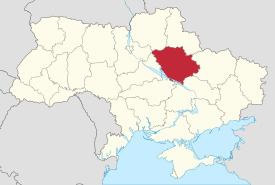
- Map of Poltava Oblast Ukraine
- Geography
- Points of interest
- Demographics
- Age structure
- Median age
- Industry
- Agriculture
- Administrative divisions
- Nomenclature
- References
Map of Poltava Oblast, Ukraine
Among other important cities, there are Horishni Plavni and Kremenchuk.
Geography
Poltava Oblast is situated in the central part of Ukraine. Located on the left bank of Dnieper, Poltava region was part of the Cossack Hetmanate. It has an area of 28,800 km². The oblast borders upon Chernihiv, Sumy, Kharkiv, Dnipropetrovsk, Kirovohrad, Cherkasy and Kyiv regions.
Points of interest
The following historic-cultural sites were nominated for the Seven Wonders of Ukraine.
Demographics
At 2005-05-01, its population was 1,584,446, and population density was 59 people per 1 km².
Age structure
0-14 years: 13.2% (male 99,444/female 93,949)15-64 years: 69.9% (male 483,389/female 530,911)65 years and over: 16.9% (male 81,435/female 164,861) (2013 official)Median age
total: 41.4 years male: 38.0 years female: 44.7 years (2013 official)Industry
The oblast’ is a center of Ukraine's oil and natural gas industry, with many wells and pipelines situated here. There is a major oil refinery plant in the city of Kremenchuk. Important iron ore processing facilities also present. In general there are 374 large industrial organization and 618 small industrial organizations.
Agriculture
In 1999 the gross grain yield was about 1452,9 thousand tons, sugar beets – 1002,900 tons, sunflower seeds – 166,200 tons, potatoes – 279,900 tons. The oblast also produced 120,500 tons of meat, 645,900 tons of milk and 423,200,00 eggs. At the beginning of 1999 there were 1,311 registered farms in the region.
Administrative divisions
The oblast is divided into 25 districts, 5 cities, 21 urban villages, and 1862 villages.
The following data incorporates the number of each type of administrative divisions of the Poltava Oblast’:
The local administration of the oblast' is controlled by the Poltava Oblast Rada. The governor of the oblast’ is the Poltava Oblast’ Rada speaker, appointed by the President of Ukraine.
Note: Asterisks (*) Though the administrative center of the rayon is housed in the city/town that its named after, cities do not answer to the rayon authorities only towns do; instead they are directly subordinated to the oblast government and therefore are not counted as part of rayon statistics.Nomenclature
Most of Ukraine's oblasts are named after their capital cities, officially referred to as "oblast centers" (Ukrainian: обласний центр, translit. oblasnyi tsentr). The name of each oblast is a relative adjective, formed by adding a feminine suffix to the name of respective center city: Poltava is the center of the Poltavs’ka oblast’ (Poltava Oblast). Most oblasts are also sometimes referred to in a feminine noun form, following the convention of traditional regional place names, ending with the suffix "-shchyna", as is the case with the Poltava Oblast, Poltavshchyna.