Point Douglas to Superior Military Road, also known as Point Douglas to St. Louis River Military Road and as Douglas Highway, was a road that ran between Point Douglas, located at the outlet of the Lower St. Croix Lake near Hastings, Minnesota, first to the falls of the St. Louis River near Thomson, Minnesota, and later extended to the mouth of the St. Louis River in Superior, Wisconsin. From Douglas Point immediately east of Hastings, Minnesota, the route connected Stillwater, Taylors Falls, Sunrise, Chengwatana, Fortuna, Scotts Corner, to Thomson and Superior. Several discontinuous sections of this road are still in use.
In 1855 the federal government began building the Point Douglas to Superior Military Road. Although intended as a highway for troop movement, this route from Hastings, Minnesota on the Mississippi River to Superior, Wisconsin on Lake Superior, was one of the first roads in Minnesota Territory and attracted a flood of civilian and commercial traffic. When Minnesota achieved statehood in 1858, responsibility for the road devolved to the state, which did not have the funds to finish the project. Although very rough and in places incomplete, the road was still the best route north until railroads were built in 1870. An alternative to the Military Road that ushered in the decline in use of the road came in 1895 when William Henry Grant built a spur of the Lake Superior and Mississippi Railroad to run to Sandstone, Minnesota. Traces of the unimproved military road can still be seen in Wild River State Park and Banning State Park.
Landmarks
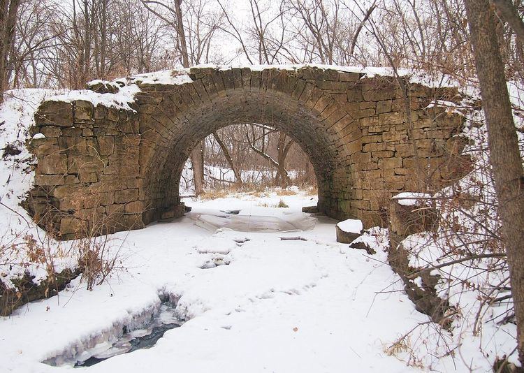
Point Douglas to Superior Military Road: Deer Creek Section, Wild River State ParkPoint Douglas–St. Louis River Road Bridge, Stillwater, MinnesotaSt. Croix Trail / County Road 21, Washington County, MinnesotaSt. Croix Trail / Minnesota Highway 95, Washington and Chisago Counties, MinnesotaLake Boulevard / U.S. Highway 8 / Minnesota Highway 95, Taylors Falls, MinnesotaWild Mountain Road / County Road 16, Shafer and Amador Townships, Chisago County, MinnesotaDeer Creek Loop, Wild River State Park, MinnesotaRiver Road, Amador and Sunrise Townships, Chisago County, MinnesotaSunrise Road / County Road 9, Sunrise Township, Chisago County, MinnesotaGovernment Road / County Road 57, Sunrise and Rushseba Townships, Chisago County, MinnesotaGovernment Road / County Road 55, Rushseba Township, Chisago County, MinnesotaGovernment Road / County Road 106, Rock Creek, Pine County, MinnesotaGovernment Road / County Highway 4, Rock Creek and Pine City Township, Pine County, MinnesotaGovernment Road, Pine City Township, Pine County, MinnesotaCross Lake Road / County Highway 9, Pine County, MinnesotaHinckley Road / County Highway 15, Mission Creek, Munch and Barry Townships, Pine County, MinnesotaGovernment Road / County Road 140, Barry Township, Pine County, MinnesotaGovernment Road, Barry and Sandstone Townships, Pine County, MinnesotaOld Military Road, Sandstone, MinnesotaWolf Creek Trail, Banning State Park, MinnesotaInterstate Highway 35, Finlayson Township, Pine County, MinnesotaOld Military Road, Norman Township, Pine County, MinnesotaMilitary Road, Norman and Windemere Townships, Pine County, MinnesotaMilitary Road / County Highway 50, Pine County, MinnesotaMilitary Road, Windemere Township, Pine County, MinnesotaMilitary Road / County Road 13, Carlton County, MinnesotaMilitary Road / Township Road 389, Carlton County, MinnesotaOriginal routingCounty Road 4, Carlton County, MinnesotaCounty Road 1, Carlton County, MinnesotaExtended routingCounty Road 4, Carlton County, MinnesotaCounty Road W, Douglas County, Wisconsin31st Avenue East, Superior, Wisconsin