
Elevation 2,677 m Prominence 947 m | Topo map NTS 92J/12 First ascent 1931 Province British Columbia Mountain range Pacific Ranges | |
 | ||
Volcanic arc/belt Canadian Cascade ArcGaribaldi Volcanic Belt Similar Pyroclastic Peak, Little Ring Mountain, Vulcan's Thumb, Round Mountain, Mount Frederick William | ||
Plinth peak starlight
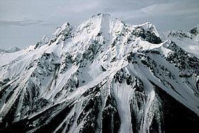
Plinth Peak, sometimes called Plinth Mountain, is the highest satellite cone of Mount Meager, and one of four overlapping volcanic cones which together form a large volcanic complex in the Garibaldi Volcanic Belt of the Canadian Cascade Arc. It is one of the most recently formed volcanic formations of the Mount Meager massif.
Contents
Map of Plinth Peak, Squamish-Lillooet C, BC, Canada
Plinth Peak is the highest volcanic peak of Mount Meager. Located on the steep north flank of Plinth is the remnant of an inner crater wall that was destroyed by a lateral blast during a period of volcanic activity about 2,350 years ago.
References
Plinth Peak Wikipedia(Text) CC BY-SA