
Topo map NTS 92J/03 Prominence 145 m | Elevation 2,349 m Mountain range Pacific Ranges | |
 | ||
Volcanic arc/belt Canadian Cascade ArcGaribaldi Volcanic Belt First ascent 1971 R. Chicoine; F. Douglas; R. Wyborn Similar Vulcan's Thumb, Little Ring Mountain, Middle Finger, One Eye Peak | ||
Flying by pyroclastic peak and mount cayley
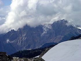
Pyroclastic Peak is the second highest of the five named volcanic peaks immediately south of Mount Cayley in British Columbia, Canada. It is steep and rotten and is located 12 km (7 mi) southwest of Callaghan Lake and 24 km (15 mi) west of Whistler. It is part of the Pacific Ring of Fire that includes over 160 active volcanoes.
Contents
- Flying by pyroclastic peak and mount cayley
- Map of Pyroclastic Peak Squamish Lillooet D BC Canada
- Flying past mount cayley and pyroclastic peak
- References
Map of Pyroclastic Peak, Squamish-Lillooet D, BC, Canada
On the south ridge of Pyroclastic Peak is a feature known as The Vulcan's Thumb which remains unclimbed because of the looseness of the rock.
Flying past mount cayley and pyroclastic peak
References
Pyroclastic Peak Wikipedia(Text) CC BY-SA