
Primary inflows Basin countries Canada Average depth 4 m (13 ft) Surface elevation 217 m Mean depth 4 m | Primary outflows Nelson River Surface area 657 km (254 sq mi) Max. depth 18 m (59 ft) Area 657 km² Catchment area 5,322 km² Outflow location Nelson River | |
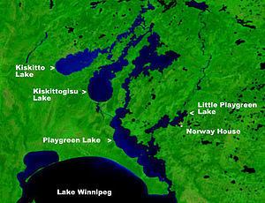 | ||
Playgreen Lake is a lake in the province of Manitoba in Canada. The lake covers an area of 657 km2 (254 sq mi) and it is a part of the Nelson River watershed. The lake is the ninth largest lake in the province. It is located along the Nelson River some 10 kilometres (6.2 mi) north from the north end of Lake Winnipeg. It was first mapped by noted British surveyor, map-maker, chief fur trader and explorer Peter Fidler in 1809.
Contents
Map of Playgreen Lake, Division No. 22, Unorganized, MB, Canada
HydrographyEdit
The Nelson River flows into Playgreen Lake from Lake Winnipeg then flows from two channels into Cross Lake.
The east channel and the Jack River flow from the southeast portion of the lake into Little Playgreen Lake then the Nelson east channel continues in a northerly direction passing through Pipestone Lake on its way to Cross Lake. The Echimamish River on this section leads to the Hayes River and York Factory on the Hudson Bay part of early Canadian canoe routes important during the North American fur trade.
The west channel flows out of the north ends of Playgreen Lake, Kiskittogisu Lake and Kiskitto Lake into Cross Lake at the Manitoba Hydro's Jenpeg Generating Station and Dam.