
Type Ice stream Terminus Floating Ice shelf | Thickness Approx. 2 km (1.2 mi) | |
 | ||
Area 175,000 km (68,000 sq mi) (whole catchment) Length Approx. 250 km (160 mi) | ||
Pine Island Glacier (PIG) is a large ice stream glacier, and the fastest melting glacier in Antarctica, responsible for about 25% of Antarctica's ice loss. The glacier ice streams flow west-northwest along the south side of the Hudson Mountains into Pine Island Bay, Amundsen Sea, Antarctica. It was mapped by the United States Geological Survey (USGS) from surveys and United States Navy (USN) air photos, 1960–66, and named by the Advisory Committee on Antarctic Names (US-ACAN) in association with Pine Island Bay.
Contents
- Map of Pine Island Glacier Antarctica
- Return to pine island glacier antarctica 2009
- Ice sheet drainage
- Weak underbelly of the West Antarctic Ice Sheet
- Acceleration and thinning
- Subglacial volcano
- On the ice
- From the sea
- References
Map of Pine Island Glacier, Antarctica
The area drained by Pine Island Glacier comprises about 10 % of the West Antarctic Ice Sheet. Satellite measurements have shown that the Pine Island Glacier Basin has a greater net contribution of ice to the sea than any other ice drainage basin in the world and this has increased due to recent acceleration of the ice stream.
The ice stream is extremely remote, with the nearest continually occupied research station at Rothera, nearly 1,300 km (810 mi) away. The area is not claimed by any nations and the Antarctic Treaty prohibits any new claims while it is in force.
Return to pine island glacier antarctica 2009
Ice sheet drainage
The Antarctic ice sheet is the largest mass of ice on earth, containing a volume of water equivalent to 57 m (187 ft) of global sea level. The ice sheet forms from snow which falls onto the continent and compacts under its own weight. The ice then moves under its own weight toward the edges of the continent. Most of this transport to the sea is by ice streams (faster moving channels of ice surrounded by slower moving ice walls) and outlet glaciers. The Antarctic ice sheet consists of the large, relatively stable, East Antarctic Ice Sheet and a smaller, less stable, West Antarctic Ice Sheet. The West Antarctic Ice Sheet is drained into the sea by several large ice streams, most of which flow into either the Ross Ice Shelf, or the Filchner-Ronne Ice Shelf. Pine Island and Thwaites Glaciers are two major West Antarctic ice streams which do not flow into a large ice shelf. They are part of an area called the Amundsen Sea Embayment. A total area of 175,000 km2 (68,000 sq mi), 10 percent of the West Antarctic Ice Sheet, drains out to the sea via Pine Island Glacier, this area is known as the Pine Island Glacier drainage basin.
Weak underbelly of the West Antarctic Ice Sheet
The Pine Island and Thwaites glaciers are two of Antarctica's five largest ice streams. Scientists have found that the flow of these ice streams has accelerated in recent years, and suggested that if they were to melt, global sea levels would rise by 1 to 2 m (3 ft 3 in to 6 ft 7 in), destabilising the entire West Antarctic Ice Sheet and perhaps sections of the East Antarctic Ice Sheet.
In 1981 Terry Hughes proposed that the region around Pine Island Bay may be a "weak underbelly" of the West Antarctic Ice Sheet. This is based on the fact that, unlike the majority of the large West Antarctic ice streams, those flowing into the Amundsen Sea are not protected from the ocean by large floating ice shelves. Also, although the surface of the glacier is above sea level, the base lies below sea level and slopes downward inland, this suggests that there is no geological barrier to stop a retreat of the ice once it has started.
Acceleration and thinning
The speed of Pine Island Glacier increased by 73 percent from 1974 to the end of 2007, with an 8 percent increase over the last 16 months of this period alone. This speed up has meant that by the end of 2007 the Pine Island Glacier system had a negative mass balance of 46 gigatonnes per year, which is equivalent to 0.13 mm (0.0051 in) per year global sea level rise. In other words, much more water was being put into the sea by PIG than was being replaced by snowfall. Measurements along the centre of the ice stream by GPS demonstrated that this acceleration is still high nearly 200 km (120 mi) inland, at around 4 percent over 2007. It has been suggested that this recent acceleration could have been triggered by warm ocean waters at the end of PIG, where it has a floating section (ice shelf) approximately 50 km (31 mi) long. It has also been shown that PIG underwent rapid thinning during the Holocene, and that this process may continue for centuries after it is initiated.
As the ice stream accelerates it is also getting steeper. The rate of thinning within the central trunk has quadrupled from 1995 to 2006. If the current rate of acceleration were to continue the main trunk of the glacier could be afloat within 100 years.
Subglacial volcano
In January 2008 the British Antarctic Survey (BAS) scientists, Hugh Corr and David Vaughan, reported that 2,200 years ago a volcano erupted under the Antarctic ice sheet. This was the biggest Antarctic eruption in the last 10,000 years. The volcano is situated in the Hudson Mountains, close to Pine Island Glacier. The eruption spread a layer of volcanic ash (or tephra) over the surface of the ice sheet. This ash was then buried under the snow and ice. Corr and Vaughan were able to map this ash layer using an airborne radar system and calculate the date of the eruption from the depth of burial of the ash. This method uses dates calculated from nearby ice cores. The presence of the volcano raises the possibility that volcanic activity could have contributed, or may contribute in the future, to increases in the flow of the glacier.
On the ice
Due to the remoteness of Pine Island Glacier, most of the information available on the ice stream comes from airborne or satellite-based measurements.
The first expedition to visit the ice stream was a United States over-snow traverse, where they spent around a week in the area of PIG during January 1961. They dug snow pits to measure snow accumulation and carried out seismic surveys to measure ice thickness. One of the scientists on this traverse was Charles R. Bentley, who claims "we didn't know we were crossing a glacier at the time." This is not surprising, because PIG is around 50 km (31 mi) wide at the point visited and at ground level cannot be visually distinguished from the surrounding ice. This expedition was called the Ellsworth Highland Traverse.
Then in the 2004/2005 field season a team of 9 using a British Antarctic Survey (BAS) Twin Otter aircraft, equipped with ice penetrating radar, completed an aerial survey of PIG and its adjacent ice sheet. The team of 7 British & 2 Americans led by Dave Vaughan & Hugh Corr flew 30 km grid patterns over the PIG until mid-January 5, mapping the sub-glacial terrain of that area roughly equal to the size of the State of Nevada.
Due to the remoteness of PIG and the logistical difficulties of caching enough fuel for the 04/05 expedition and future project(s), BAS used the resources of the United States Antarctic Program (USAP) and their ski-equipped LC130 aircraft.
After many weeks of weather delays the first four men (Ben Partan, Rob Smith, Dave Anderson & Martin Bell) arrived from McMurdo on 11/9/04 and began to establish camp and build a skiway for the C130’s. Camp was established on the upper end of the ice stream at S77.76973 x W095.12713. The remaining members of the team arrived from Rothera approximately 10 days later in the Twin Otter, flown by survey pilot Dave Leatherdale.
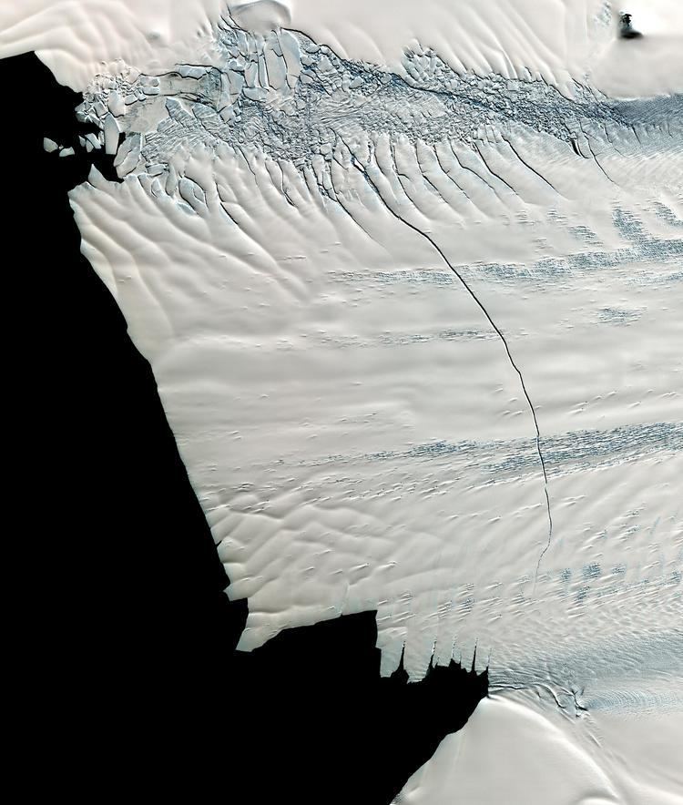
Because of unusually good weather in the area that season the survey completed flying their grids early (mid-January) and began flying 15 km grids of Thwaites Glacier for a USAP expedition who had been experiencing unusually poor weather in their area that year. Flying over Antarctica’s Pine Island Glacier in a DC-8 research plane, scientists participating in NASA’s IceBridge mission made a startling discovery on October 14, 2011: a massive crack running about 29 kilometers (18 mi) across the glacier’s floating tongue. The rift is 80 metres (260 feet) wide on average and 50 to 60 meters (160 to 200 ft) deep, and it marks the moment of creation for a new iceberg that will span about 880 square kilometers (340 square miles) once it breaks loose from the glacier.
All survey grids having been completed by the end of January, the survey crew flew back to Rothera leaving the two Americans and two British to dismantle the camp. A week later the remaining team members flew back to McMurdo leaving a fuel cache for future expeditions.
Another team from the British Antarctic Survey arrived at the ice stream on 8 December 2006 for the first of two field seasons. In the second field season, they spent three months there from November 2007 to February 2008. Work on the glacier included radar measurements and seismic surveys.
In January 2008 Bob Bindschadler (NASA) landed on the floating ice shelf of PIG, this is at the downstream end where it floats on the sea. This landing, by a Twin Otter plane fitted with skis, was the first ever landing on this ice shelf. The reason for landing on the ice shelf was for a reconnaissance mission to investigate the feasibility of drilling through around 500 m (1,600 ft) of ice, to lower instruments into the ocean cavity below. It is hoped that this will provide important information on the link between the ocean and Pine Island Glacier. It was decided that the small crevasse free area was too hard for further landings and so further fieldwork had to be postponed. Therefore, two GPS units and a weather station were positioned as near as possible to PIG.
Since then, the National Science Foundation has decided to establish a helicopter camp for the scientists to safely study the ice-ocean interaction. During the 2010–11 summer field season in Antarctica, it is planned that tractors and sleds will haul all of the equipment needed to establish a camp near the ice shelf. A tractor train traverse of about 700 km (430 mi) is needed to deliver the materials. The plan over the following two field seasons, 2011–12 and 2012–13, is for scientists to use helicopters to fly to sites on the ice shelf, where they will deploy specially designed profilers down through the ice shelf to measure various ocean properties.
2011-2012 field season: after five weeks of delays, the camp staff was finally able to establish the Main Camp just before New Years. The following week Dr Bindschadler and his team were able to arrive. Due to additional weather delays, the helicopters weren't able to arrive by the NSF 'drop dead' date and the field season was essentially cancelled. Fortunately limited science was still accomplished by the team thanks to a series of flights by KBA back onto the glacier; its seems that conditions had changed drastically since the last twin otter flights.
The British Antarctic Survey deployed a small team of four (Dr Andrew Smith, Gabriel Chevailler, Ashly Fusiarski, Ian Hey) during the 2011-12 summer field season to carry out a series of seismic and radar surveys on PIG. They also installed a series of overwintering GPS stations. During this same field season, a separate BAS team (Dr Mark Clilverd, Tom Stroud) was inputted to the field parties location and they installed an overwintering autonomous VLF station. This was followed by a radar traverse upstream using skidoos. This survey linked previous radar lines.
From the sea
The first ship to reach Pine Island Glacier's ice shelf, in Pine Island Bay, was the USS/USCGC Glacier in 1985. This ship was an icebreaker operated by the U.S. Coast Guard. The mission, known as Deep Freeze, had scientists on board who took sediment samples from the ocean floor.
During the summer field season, over two months from January to February 2009, researchers aboard the U.S. Antarctic Program research vessel Nathaniel B. Palmer reached the ice shelf. This was the second time that the Palmer had successfully made it up to the glacier, the first time being in 1994. In collaboration with the British, the scientists used a robotic submarine to explore the glacier-carved channels on the continental shelf as well as the cavity below the ice shelf and glacier. The submarine, known as Autosub 3, was developed and built at the National Oceanography Centre in the UK. It completed six successful missions, travelling a total of 500 km (310 mi) under the ice shelf. Autosub is able to map the base of the ice shelf as well as the ocean floor and take various measurements and samples of the water on the way. The success of Autosub 3 was particularly notable because its predecessor Autosub 2 was lost beneath the Fimbul Ice Shelf on only its second such mission.