
Listing Ultra Prominence 2,455 m | Elevation 2,765 m | |
 | ||
Similar Pico Bolívar, Pico Humboldt, Pico Bonpland, Pico Pan de Azúcar, Auyán‑tepui | ||
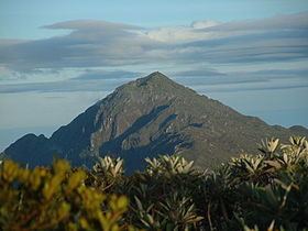
Pico Naiguatá is the summit of a mountain in South America near Caracas, Venezuela, part of the Venezuelan Coastal Range, of which it is the highest peak. It is situated on the border of the Venezuelan states Miranda and Vargas. With a summit elevation of 2,765 metres (9,072 ft) and a topographic isolation of 2,455 metres (8,054 ft) above sea level, it is the highest point in both of these states and the fourth highest of the Caribbean after "Pico Simón Bolivar" and "Pico Cristóbal Colón" of The Santa Marta Coastal range in Colombia and "Pico Duarte" in the Dominican Republic.
Map of Pico Naiguat%C3%A1, Miranda, Venezuela
References
Pico Naiguatá Wikipedia(Text) CC BY-SA