
Constructed 1972 | Length 24.02 km | |
 | ||
Existed: March 14, 1972 – present Counties | ||
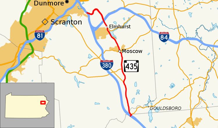
Pennsylvania Route 435 (PA 435) is a 14.9-mile-long (24.0 km) state highway located in Monroe, Wayne, and Lackawanna Counties in Pennsylvania. The southern terminus is at Interstate 380 (I-380) near Gouldsboro. The northern terminus is at I-84 and I-380 in Dunmore. The route heads north from I-380 and the southern terminus of PA 507 in Monroe County as a four-lane road, passing through a small section of Wayne County before entering Lackawanna County. PA 435 becomes a two-lane road at the PA 307 junction and continues north to intersect PA 502 in Daleville and PA 690 in Moscow. After intersecting PA 590, the route becomes a four-lane divided highway and intersects PA 348 before merging into I-84/I-380.
Contents
Map of PA-435, Pennsylvania, USA
The PA 435 alignment follows the Philadelphia and Great Bend Turnpike or Drinker Turnpike, a turnpike between Philadelphia and Great Bend chartered in 1811 and built in the 1820s. The road became part of the Lackawanna Trail, a paved auto trail between Easton and the New York border. The Lackawanna Trail became PA 2, which ran between Philadelphia and Great Bend, in 1924 and U.S. Route 611 (US 611), which ran between Philadelphia and Scranton, in 1926. The PA 2 designation was removed from US 611 two years later. Portions of US 611 south of Scranton were widened between the 1930s and 1960s. US 611 was decommissioned in 1972 and PA 435 replaced the route between Gouldsboro and Dunmore.
Route description
PA 435 begins at an interchange with I-380's Exit 13 at the northwestern corner of Gouldsboro State Park in Coolbaugh Township, Monroe County, heading northeast as a two-lane undivided road. Immediately after beginning, the route reaches a junction with the southern terminus of PA 507 and turns northwest onto a four-lane divided highway. PA 435 heads northwestward out of Monroe County and passes through a corner of Lehigh Township in Wayne County before entering Lackawanna County at the crossing of the Lehigh River, becoming a four-lane undivided road. The roadway parallels a distance from I-380 through the rural stretches of Clifton Township. The highway continues north through Clifton, passing west of Big Bass Lake and soon the Covington Industrial Park. PA 435 continues a close parallel with the interstate as it passes east of Covington Lake and enters Covington Township. Just north of the township line, PA 435 forks to the northeast at a junction with PA 307 (the Scranton-Pocono Highway).
PA 435 continues to the northeast through the residential regions of Covington Township as a two-lane road, passing into the small hamlet of Daleville, where it gains a center left-turn lane. Through Daleville, the route remains residential, and enters the commercial hamlet and an intersection with PA 502 (Daleville Highway). PA 435 continues northward out of Daleville and begins to parallel with the Delaware–Lackawanna Railroad, narrowing to a two-lane road and briefly gaining a second southbound lane. The highway heads past the Saint Catherine's Cemetery and soon crosses into the borough of Moscow as a two-lane road. Heading through Moscow, PA 435 gains the moniker of South Main Street, and makes a large curve along the railroad line to an intersection with PA 690 (New Street). Here, PA 435 and PA 690 begin a concurrency through downtown Moscow, passing the local train station and at the intersection with Church Street, PA 690 turns west onto Church while PA 435 continues north along North Main Street.
Leaving downtown Moscow, PA 435 continues northward aside the Delaware–Lackawanna Railroad line. The forestry soon takes over and residences become sporadic as the route winds its way through Elmhurst Township. The rail line moves to the east a bit as both the railroad and PA 435 pass the Elmhurst Reservoir. Passing Fairview Memorial Park, Blue Shutters Road (State Route 2010) soon merges in. After the reservoir ends, PA 435 crosses under the curving rail line and continues northward into the hamlet of Elmhurst. Through Elmhurst, PA 435 begins a parallel with PA 590, which soon merges in with the main route. PA 435 widens to a four-lane divided highway and continues northwestward out of Elmhurst, crossing over I-84. After this bridge, PA 348 merges into the highway. PA 348 ends at southbound PA 435 while northbound PA 435 passes over PA 348 with a ramp connection to the route. The highway winds along the Roaring Brook into Dunmore, following the Drinker Turnpike until it forks. PA 435 soon turns to the northwest once again and merges into Exit 2 on the concurrent I-84 and I-380 in Dunmore.
History
In 1811, the Philadelphia and Great Bend Turnpike, a private turnpike, was chartered to run between Philadelphia and Great Bend. This turnpike was built to attract settlers to rural Pennsylvania. The section through Covington Township was built as a plank road between 1819 and 1826 by John Delong under the employment of Henry Drinker. The Philadelphia and Great Bend Turnpike, which was also known as the Drinker Turnpike, was built from 1826 to 1828.
When Pennsylvania legislated routes in 1911, what is now PA 435 was designated as part of Legislative Route 168, which ran from Stroudsburg to Scranton. In 1921, the Lackawanna Trail was built as a paved auto trail running from Easton north through Stroudsburg to Scranton and the New York border. After being constructed, the trail was one of the best paved roads in the eastern part of the United States. The Lackawanna Trail was designated as PA 2 in 1924, with the route running between Philadelphia and the New York border in Great Bend. When the U.S. Highway System was designated in 1926, US 611 was designated to run between Philadelphia and Scranton concurrent with PA 2, including the road between Gouldsboro and Dunmore. The concurrent PA 2 designation was removed from US 611 in 1928.
US 611 was widened to a multilane road from a point north of the PA 507 intersection north to the newly constructed PA 307 in the 1930s. In the 1940s, the route was widened south to PA 507 along with a short stretch to the north of PA 348. The section of US 611 between PA 590 and Dunmore was upgraded to a divided highway in 1958, with the section of the route leading into Dunmore moved to a new alignment. In 1969, an interchange with I-81E (now I-380) was built with US 611 near the southern terminus of PA 507, at which point US 611 headed south along the freeway. On December 3, 1971, the American Association of State Highway Officials approved the elimination of the US 611 designation. On March 14, 1972, US 611 was decommissioned and PA 435 replaced the route between I-380 in Gouldsboro and I-84/I-380 in Dunmore. Signs were changed by April of that year.