
Existed: 1946 – present Constructed 1946 | Length 26.93 km | |
 | ||
West end: PA 171 in Ararat Township Counties | ||
Pennsylvania Route 370 (designated by the Pennsylvania Department of Transportation as SR 370) is a 16.73-mile-long (26.92 km) state highway located in Susquehanna and Wayne counties in Pennsylvania. The western terminus is at Route 171 in East Ararat. The eastern terminus is at Route 191 in Buckingham Township near Hancock, New York. Route 370 was first designated by the Pennsylvania Department of Highways in 1928 from the intersection with then Route 70 in East Ararat to an intersection with Route 570 in the hamlet of Preston Park (in Preston Township). The route was extended to an intersection with Route 90 (now Route 191) in 1946, when the 23-mile-long (37 km) Route 570 was decommissioned.
Contents
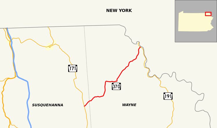
Map of PA-370, Pennsylvania, USA
Route description
Route 370 begins at an intersection with Route 171 in the hamlet of East Ararat in Ararat Township. Route 370 heads to the northeast through tree patches and fields before entering a dense patch of woods. Upon leaving the woods, Route 370 crosses the county line from Susquehanna County to Wayne County and enters Preston Township. At the intersection with Mud Pond Road, the highway bends eastward but returns to its northeastern progression at an intersection with Blewett Road. Route 370 turns to the east once again and enters the community of Orson.
In Orson, Route 370 passes local farms and some houses. Shortly after it intersects with the northern terminus of Route 670 (Belmont Turnpike North), which continues north as Oxbow Road. Route 370 continues eastward out of Orson, passing Orson Pond and several residences in a mainly rural area before entering the hamlet of Poyntelle. In Poyntelle, the highway passes to the north of Lake Lorain and Lake Lorain Golf Course. At the intersection with Lake Lorain Road, Route 370 turns to the northeast once again, paralleling Cribbs Road into downtown Poyntelle. The two roads cross a former alignment of the Ontario and Western Railroad before merging just north of Poyntelle.
After Cribbs Road, Route 370 turns northward, entering Lakewood in dense woods. The route passes Little Hickory Lake and soon Hickory Lake. After entering the Tamarack Swamp and passing a local pond, Route 370 makes a gradual curve to the east at an intersection with Dixie Highway. The route remains rural, paralleling the Ontario and Western Railroad alignment into the hamlet of Tallmanville. In Tallmanville, the route is primarily residential, passing the local school. At the intersection with Como Road, Route 370 turns to the northeast, paralleling the railroad alignment into the hamlet of Preston Park.
Through Preston Park, Route 370 intersects with an old alignment of itself twice before coming to the main intersection in town, the northern terminus of Route 247 (Creamton Drive) and its continuation Rabbit Run Road. The road turns northeastward and passes several residences before intersecting with Shehawken Road, where the road becomes mainly wooded once again. The route parallels an alignment of former State Route 570 and the former Ontario and Western Railroad into Buckingham Township, where the route enters the hamlet of Starlight. In Starlight, Route 370 passes the former Ontario and Western station and turns eastward once the old alignment of Route 570 merges in. After passing a pond, the highway leaves Starlight and continues northeastward in dense forestry. A short while later, the route turns northward and weaves to an intersection with Route 191 (the Hancock Highway) in Buckingham Township. This serves as the northern terminus of Route 370.
History
Route 370 was first signed along Crosstown Highway in 1928 from its current western terminus of Route 171 (then designated Route 70) in Ararat Township to an intersection with Route 570, another spur of Route 70 in the hamlet of Preston Park. The entire stretch was paved by the Pennsylvania Department of Highways in 1932. At that point, Route 570 used the current alignment from the intersection with Shehawken Road to the intersection with Route 90 (now Route 191). Route 570, along with Route 470 and Route 270 were decommissioned in 1946 by the Department of Highways, and Route 370 was extended along the alignment from Shehawken Road to Route 90. In 1961, Route 370's termini both changed to Route 171 and Route 191 when both were renumbered to prevent duplication with Interstate 70 and Interstate 90.