
Existed: 1928 – present Constructed 1928 | Length 23.8 km | |
 | ||
Counties Allegheny County, Pennsylvania, Westland County, Pennsylvania | ||
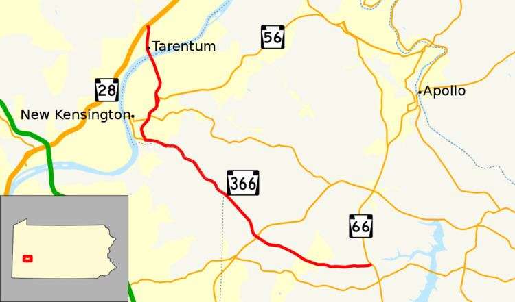
Pennsylvania Route 366 (PA 366) is a 14.8-mile-long (23.8 km) state highway located in Allegheny and Westmoreland Counties in Pennsylvania. The western terminus is at PA 28 in Tarentum. The eastern terminus is at PA 66 in Murrysville. The last 1/2 mile of the Red Belt route of the Allegheny County belt system runs along PA 366 in Tarentum from its eastbound beginning at the PA 28 interchange to the intersection of Freeport Rd. and Ross St. where the Red Belt terminates.
Contents
Map of PA-366, Pennsylvania, USA
Route description
PA 366 begins at an interchange with the PA 28 freeway in Fawn Township, Allegheny County, heading south on Bull Creek Road, a four-lane divided highway that is part of the Red Belt of the Allegheny County belt system. Within the interchange, the road crosses into Tarentum and passes through wooded areas. Farther south, the route becomes Ross Street and passes a mix of homes and businesses. At the Seventh Avenue intersection, the Red Belt ends and the median of the road widens as it comes to a bridge over Norfolk Southern's Conemaugh Line, reaching an eastbound exit and westbound entrance with First Avenue. After this, PA 366 heads onto the George D. Stuart Bridge over the Allegheny River. Upon crossing the river, the route enters New Kensington in Westmoreland County, becoming four-lane undivided Tarentum Bridge Road, passing between residential neighborhoods to the west and businesses to the east. The road continues south and gains a center left-turn lane, running through more commercial areas. PA 366 heads into woods and becomes a three-lane road with one eastbound lane and two westbound lanes, coming to an interchange with PA 56. At this point, PA 366 heads south concurrent with PA 56 on four-lane divided Stevenson Boulevard, curving southwest through more wooded areas before turning south and running to the east of Valley High School. The road comes to an intersection with the western terminus of PA 780 prior to passing a few businesses, with PA 56 splitting to the west. At this point, PA 366 becomes concurrent with PA 56 Truck and turns southwest, running near more homes and businesses as it becomes a two-lane undivided road with frontage roads. The frontage roads end and the route curves south past more commercial establishments. PA 366 merges southeast onto Freeport Street and turns south into Lower Burrell.
At this point, PA 56 Truck turns west onto 2nd Street and PA 366 turns east onto Greensburg Road, heading into wooded areas with some residential and commercial development. The road briefly forms the border between New Kensington to the north and Lower Burrell to the south before fully enterting Lower Burrell again as it continues to the north of Pucketa Creek. The route continues southeast through more woodland with homes and businesses, crossing the Pucketa Creek into Plum in Allegheny County. PA 366 continues past more wooded residential areas, crossing into Murrysville in Westmoreland County. The road crosses the Pucketa Creek into Upper Burrell Township and continues southeast. The route widens into a four-lane divided highway and turns south, heading back into Murrysville and heading through woods, curving southeast to come to an interchange with PA 380. Past this, PA 366 heads into Washington Township and runs through more woodland with some homes, curving to the east-southeast. The route heads to the east as it enters a mix of farm fields and woods with a few residences, ending at an intersection with PA 66.